
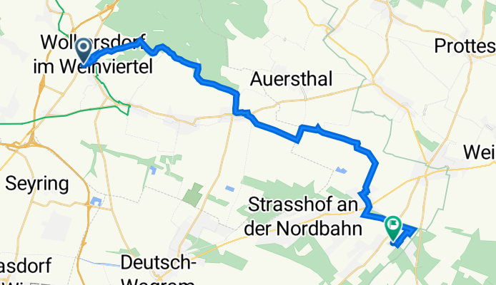
Energieweg Gravel: Wolkersdorf-Gänserndorf
A cycling route starting in Wolkersdorf im Weinviertel, Lower Austria, Austria.
Overview
About this route
- 1 h 31 min
- Duration
- 24.1 km
- Distance
- 112 m
- Ascent
- 182 m
- Descent
- 15.9 km/h
- Avg. speed
- 262 m
- Avg. speed

Route photos


Route quality
Waytypes & surfaces along the route
Waytypes
Quiet road
20.6 km
(85 %)
Track
1.3 km
(5 %)
Surfaces
Paved
11.1 km
(46 %)
Unpaved
10 km
(41 %)
Asphalt
10.8 km
(45 %)
Gravel
9.5 km
(39 %)
Continue with Bikemap
Use, edit, or download this cycling route
You would like to ride Energieweg Gravel: Wolkersdorf-Gänserndorf or customize it for your own trip? Here is what you can do with this Bikemap route:
Free features
- Save this route as favorite or in collections
- Copy & plan your own version of this route
- Sync your route with Garmin or Wahoo
Premium features
Free trial for 3 days, or one-time payment. More about Bikemap Premium.
- Navigate this route on iOS & Android
- Export a GPX / KML file of this route
- Create your custom printout (try it for free)
- Download this route for offline navigation
Discover more Premium features.
Get Bikemap PremiumFrom our community
Other popular routes starting in Wolkersdorf im Weinviertel
 Windischhütte über Kahlenberg
- Distance
- 83.6 km
- Ascent
- 1,153 m
- Descent
- 1,150 m
- Location
- Wolkersdorf im Weinviertel, Lower Austria, Austria
 Korneuburg
- Distance
- 51.6 km
- Ascent
- 120 m
- Descent
- 120 m
- Location
- Wolkersdorf im Weinviertel, Lower Austria, Austria
 Kahlenberg + Buschberg
- Distance
- 119.1 km
- Ascent
- 1,454 m
- Descent
- 1,446 m
- Location
- Wolkersdorf im Weinviertel, Lower Austria, Austria
 Rendezvpus
- Distance
- 35 km
- Ascent
- 37 m
- Descent
- 38 m
- Location
- Wolkersdorf im Weinviertel, Lower Austria, Austria
 Untere Hofgärten, Wolkersdorf im Weinviertel nach Untere Hofgärten, Wolkersdorf im Weinviertel
- Distance
- 6.3 km
- Ascent
- 37 m
- Descent
- 37 m
- Location
- Wolkersdorf im Weinviertel, Lower Austria, Austria
 Prottes - Spannberg - Sulz ...
- Distance
- 88.9 km
- Ascent
- 741 m
- Descent
- 745 m
- Location
- Wolkersdorf im Weinviertel, Lower Austria, Austria
 Runde Wolkersdorf-Unterolberndorf
- Distance
- 33.7 km
- Ascent
- 492 m
- Descent
- 492 m
- Location
- Wolkersdorf im Weinviertel, Lower Austria, Austria
 Radrunde durch Gemeinde Wolkersdorf im Weinviertel
- Distance
- 28.7 km
- Ascent
- 45 m
- Descent
- 43 m
- Location
- Wolkersdorf im Weinviertel, Lower Austria, Austria
Open it in the app