

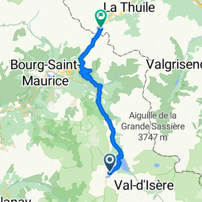
466 Rue Saint-Pierre aux Liens, Tignes à 218 Rue du Cachay, Val-d'Isère
A cycling route starting in Tignes, Auvergne-Rhône-Alpes, France.
Overview
About this route
- 2 h 28 min
- Duration
- 25.5 km
- Distance
- 766 m
- Ascent
- 476 m
- Descent
- 10.3 km/h
- Avg. speed
- 2,112 m
- Avg. speed
Continue with Bikemap
Use, edit, or download this cycling route
You would like to ride 466 Rue Saint-Pierre aux Liens, Tignes à 218 Rue du Cachay, Val-d'Isère or customize it for your own trip? Here is what you can do with this Bikemap route:
Free features
- Save this route as favorite or in collections
- Copy & plan your own version of this route
- Sync your route with Garmin or Wahoo
Premium features
Free trial for 3 days, or one-time payment. More about Bikemap Premium.
- Navigate this route on iOS & Android
- Export a GPX / KML file of this route
- Create your custom printout (try it for free)
- Download this route for offline navigation
Discover more Premium features.
Get Bikemap PremiumFrom our community
Other popular routes starting in Tignes
 Tignes - Col de Petit st. Bernard
- Distance
- 39.8 km
- Ascent
- 1,121 m
- Descent
- 1,057 m
- Location
- Tignes, Auvergne-Rhône-Alpes, France
 Tignes - Col D´Iseran
- Distance
- 30.6 km
- Ascent
- 1,209 m
- Descent
- 583 m
- Location
- Tignes, Auvergne-Rhône-Alpes, France
 to furnicular
- Distance
- 0.6 km
- Ascent
- 12 m
- Descent
- 32 m
- Location
- Tignes, Auvergne-Rhône-Alpes, France
 Guillestre - Tignes
- Distance
- 231.2 km
- Ascent
- 4,232 m
- Descent
- 5,325 m
- Location
- Tignes, Auvergne-Rhône-Alpes, France
 3.Route des Grandes Alpes - Day Three
- Distance
- 109.8 km
- Ascent
- 1,851 m
- Descent
- 2,250 m
- Location
- Tignes, Auvergne-Rhône-Alpes, France
 Col de l'Iseran and Mont Cenis
- Distance
- 72 km
- Ascent
- 1,711 m
- Descent
- 1,739 m
- Location
- Tignes, Auvergne-Rhône-Alpes, France
 Tignes Cormet De Roselend Val Thorens 151km
- Distance
- 151.4 km
- Ascent
- 3,147 m
- Descent
- 2,928 m
- Location
- Tignes, Auvergne-Rhône-Alpes, France
 Tignes-Val Thorens-Cormet d´Acheres-Col du Pre-Cormet de Roseland-Tignes
- Distance
- 231.2 km
- Ascent
- 5,026 m
- Descent
- 5,059 m
- Location
- Tignes, Auvergne-Rhône-Alpes, France
Open it in the app