
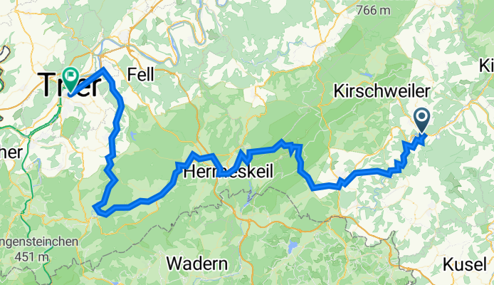
Idar-Oberstein nach Gartenfeldstr., Trier
A cycling route starting in Idar-Oberstein, Rhineland-Palatinate, Germany.
Overview
About this route
- 7 h 26 min
- Duration
- 102 km
- Distance
- 2,142 m
- Ascent
- 2,264 m
- Descent
- 13.7 km/h
- Avg. speed
- 756 m
- Avg. speed
Route quality
Waytypes & surfaces along the route
Waytypes
Path
47.2 km
(46 %)
Quiet road
17.2 km
(17 %)
Surfaces
Paved
95.1 km
(93 %)
Unpaved
0.7 km
(<1 %)
Asphalt
68.9 km
(68 %)
Paved (undefined)
25.4 km
(25 %)
Continue with Bikemap
Use, edit, or download this cycling route
You would like to ride Idar-Oberstein nach Gartenfeldstr., Trier or customize it for your own trip? Here is what you can do with this Bikemap route:
Free features
- Save this route as favorite or in collections
- Copy & plan your own version of this route
- Sync your route with Garmin or Wahoo
Premium features
Free trial for 3 days, or one-time payment. More about Bikemap Premium.
- Navigate this route on iOS & Android
- Export a GPX / KML file of this route
- Create your custom printout (try it for free)
- Download this route for offline navigation
Discover more Premium features.
Get Bikemap PremiumFrom our community
Other popular routes starting in Idar-Oberstein
 RLP4: Idar Oberstein - Kell a. See 66km 960hm
- Distance
- 66.2 km
- Ascent
- 794 m
- Descent
- 573 m
- Location
- Idar-Oberstein, Rhineland-Palatinate, Germany
 Idar-Oberstein - Bingen - Mainz CLONED FROM ROUTE 154530
- Distance
- 108.2 km
- Ascent
- 163 m
- Descent
- 307 m
- Location
- Idar-Oberstein, Rhineland-Palatinate, Germany
 Teil 4 Idar-Oberstein nach Schwarzenbach
- Distance
- 56.5 km
- Ascent
- 597 m
- Descent
- 460 m
- Location
- Idar-Oberstein, Rhineland-Palatinate, Germany
 20150621 Nahe Hit Radel mit
- Distance
- 109.3 km
- Ascent
- 227 m
- Descent
- 361 m
- Location
- Idar-Oberstein, Rhineland-Palatinate, Germany
 20130616 Idar-Oberstein - Bingen - Mainz
- Distance
- 109.1 km
- Ascent
- 166 m
- Descent
- 304 m
- Location
- Idar-Oberstein, Rhineland-Palatinate, Germany
 Rennradrunde 38Km, Rilchenberg,Oberhambach,Kronweiler,Rilchenberg CLONED FROM ROUTE 623876
- Distance
- 38 km
- Ascent
- 600 m
- Descent
- 600 m
- Location
- Idar-Oberstein, Rhineland-Palatinate, Germany
 Nahe2
Nahe2- Distance
- 75.4 km
- Ascent
- 397 m
- Descent
- 580 m
- Location
- Idar-Oberstein, Rhineland-Palatinate, Germany
 Idarer Wald
- Distance
- 6.3 km
- Ascent
- 267 m
- Descent
- 263 m
- Location
- Idar-Oberstein, Rhineland-Palatinate, Germany
Open it in the app