

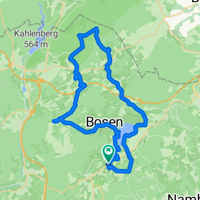
Tag 6 Feilbingert - Winterbach
A cycling route starting in Oberthal, Saarland, Germany.
Overview
About this route
- 6 h 34 min
- Duration
- 81.1 km
- Distance
- 1,365 m
- Ascent
- 1,388 m
- Descent
- 12.4 km/h
- Avg. speed
- 485 m
- Avg. speed

Route quality
Waytypes & surfaces along the route
Waytypes
Track
22.2 km
(27 %)
Path
17.2 km
(21 %)
Surfaces
Paved
71.1 km
(88 %)
Unpaved
6 km
(7 %)
Asphalt
52 km
(64 %)
Paved (undefined)
18.8 km
(23 %)
Continue with Bikemap
Use, edit, or download this cycling route
You would like to ride Tag 6 Feilbingert - Winterbach or customize it for your own trip? Here is what you can do with this Bikemap route:
Free features
- Save this route as favorite or in collections
- Copy & plan your own version of this route
- Sync your route with Garmin or Wahoo
Premium features
Free trial for 3 days, or one-time payment. More about Bikemap Premium.
- Navigate this route on iOS & Android
- Export a GPX / KML file of this route
- Create your custom printout (try it for free)
- Download this route for offline navigation
Discover more Premium features.
Get Bikemap PremiumFrom our community
Other popular routes starting in Oberthal
 Nahe-Radweg
- Distance
- 133.7 km
- Ascent
- 1,818 m
- Descent
- 2,198 m
- Location
- Oberthal, Saarland, Germany
 Schaumbergtrails mit Hofgut Imsbach
- Distance
- 43.8 km
- Ascent
- 849 m
- Descent
- 849 m
- Location
- Oberthal, Saarland, Germany
 Ob-N-Nahe-Eiw-Peterberg
- Distance
- 13.3 km
- Ascent
- 418 m
- Descent
- 136 m
- Location
- Oberthal, Saarland, Germany
 20141026_100525
- Distance
- 36 km
- Ascent
- 427 m
- Descent
- 424 m
- Location
- Oberthal, Saarland, Germany
 Nahe-Quellen-weg
- Distance
- 4.6 km
- Ascent
- 131 m
- Descent
- 155 m
- Location
- Oberthal, Saarland, Germany
 WND Land (Marpingen included)
- Distance
- 46.8 km
- Ascent
- 804 m
- Descent
- 804 m
- Location
- Oberthal, Saarland, Germany
 Bostalsee/Schaumberg Runde
- Distance
- 49.7 km
- Ascent
- 578 m
- Descent
- 578 m
- Location
- Oberthal, Saarland, Germany
 Güdesw.-Buchwald-Bost.See-
- Distance
- 28.2 km
- Ascent
- 336 m
- Descent
- 342 m
- Location
- Oberthal, Saarland, Germany
Open it in the app