

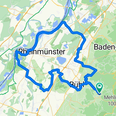
Bühlerhöhe/Plättig, Rastatt nach Bühlerhöhe/Plättig, Rastatt
A cycling route starting in Bühlertal, Baden-Württemberg, Germany.
Overview
About this route
- 1 h 32 min
- Duration
- 12.3 km
- Distance
- 352 m
- Ascent
- 350 m
- Descent
- 8 km/h
- Avg. speed
- 806 m
- Avg. speed

Route quality
Waytypes & surfaces along the route
Waytypes
Track
10.1 km
(82 %)
Path
0.9 km
(8 %)
Surfaces
Paved
2.1 km
(17 %)
Unpaved
10 km
(81 %)
Gravel
9 km
(73 %)
Asphalt
1.7 km
(14 %)
Continue with Bikemap
Use, edit, or download this cycling route
You would like to ride Bühlerhöhe/Plättig, Rastatt nach Bühlerhöhe/Plättig, Rastatt or customize it for your own trip? Here is what you can do with this Bikemap route:
Free features
- Save this route as favorite or in collections
- Copy & plan your own version of this route
- Sync your route with Garmin or Wahoo
Premium features
Free trial for 3 days, or one-time payment. More about Bikemap Premium.
- Navigate this route on iOS & Android
- Export a GPX / KML file of this route
- Create your custom printout (try it for free)
- Download this route for offline navigation
Discover more Premium features.
Get Bikemap PremiumFrom our community
Other popular routes starting in Bühlertal
 3 Stunden Strecke
- Distance
- 36.5 km
- Ascent
- 958 m
- Descent
- 958 m
- Location
- Bühlertal, Baden-Württemberg, Germany
 Schwimmbad Bühlertal - Hornisgrinde Rundweg
- Distance
- 44.4 km
- Ascent
- 1,131 m
- Descent
- 1,128 m
- Location
- Bühlertal, Baden-Württemberg, Germany
 2011-04-03 Tour
- Distance
- 29.8 km
- Ascent
- 893 m
- Descent
- 893 m
- Location
- Bühlertal, Baden-Württemberg, Germany
 Herrenwies 35, Forbach nach Freudenstädter Straße 57, Loßburg
- Distance
- 50.4 km
- Ascent
- 782 m
- Descent
- 961 m
- Location
- Bühlertal, Baden-Württemberg, Germany
 Drei Täler Tour
- Distance
- 74.9 km
- Ascent
- 2,435 m
- Descent
- 2,342 m
- Location
- Bühlertal, Baden-Württemberg, Germany
 Permanente Bühlertal-Rheintal Tour
- Distance
- 69.8 km
- Ascent
- 290 m
- Descent
- 404 m
- Location
- Bühlertal, Baden-Württemberg, Germany
 Von Bühlertal bis Bundenthal
- Distance
- 145.1 km
- Ascent
- 1,902 m
- Descent
- 2,204 m
- Location
- Bühlertal, Baden-Württemberg, Germany
 Mountainbiketour 005 mit 33Km und 950Hm
- Distance
- 32.1 km
- Ascent
- 868 m
- Descent
- 868 m
- Location
- Bühlertal, Baden-Württemberg, Germany
Open it in the app