
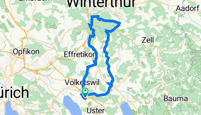
Swisstopo Route
A cycling route starting in Nänikon / Nänikon (Dorfkern), Canton of Zurich, Switzerland.
Overview
About this route
- 3 h 11 min
- Duration
- 40.5 km
- Distance
- 643 m
- Ascent
- 645 m
- Descent
- 12.7 km/h
- Avg. speed
- 686 m
- Avg. speed
Route quality
Waytypes & surfaces along the route
Waytypes
Road
16.2 km
(40 %)
Quiet road
13.9 km
(34 %)
Surfaces
Paved
36.6 km
(90 %)
Unpaved
3.9 km
(10 %)
Asphalt
35.3 km
(87 %)
Gravel
2.8 km
(7 %)
Continue with Bikemap
Use, edit, or download this cycling route
You would like to ride Swisstopo Route or customize it for your own trip? Here is what you can do with this Bikemap route:
Free features
- Save this route as favorite or in collections
- Copy & plan your own version of this route
- Sync your route with Garmin or Wahoo
Premium features
Free trial for 3 days, or one-time payment. More about Bikemap Premium.
- Navigate this route on iOS & Android
- Export a GPX / KML file of this route
- Create your custom printout (try it for free)
- Download this route for offline navigation
Discover more Premium features.
Get Bikemap PremiumFrom our community
Other popular routes starting in Nänikon / Nänikon (Dorfkern)
 Swisstopo Route
- Distance
- 40.5 km
- Ascent
- 643 m
- Descent
- 645 m
- Location
- Nänikon / Nänikon (Dorfkern), Canton of Zurich, Switzerland
 Schwerzistrasse, Nänikon nach Schwerzistrasse, Nänikon
- Distance
- 45.6 km
- Ascent
- 379 m
- Descent
- 365 m
- Location
- Nänikon / Nänikon (Dorfkern), Canton of Zurich, Switzerland
 Sternenberg
- Distance
- 71.2 km
- Ascent
- 764 m
- Descent
- 764 m
- Location
- Nänikon / Nänikon (Dorfkern), Canton of Zurich, Switzerland
 Schwerzistrasse, Nänikon nach Schwerzistrasse, Nänikon
- Distance
- 39.7 km
- Ascent
- 465 m
- Descent
- 462 m
- Location
- Nänikon / Nänikon (Dorfkern), Canton of Zurich, Switzerland
 Schwerzistrasse, Nänikon nach Schwerzistrasse, Nänikon
- Distance
- 33.5 km
- Ascent
- 424 m
- Descent
- 425 m
- Location
- Nänikon / Nänikon (Dorfkern), Canton of Zurich, Switzerland
 Hulftegg-Ghöch
- Distance
- 77.2 km
- Ascent
- 1,003 m
- Descent
- 1,004 m
- Location
- Nänikon / Nänikon (Dorfkern), Canton of Zurich, Switzerland
 Näniker Wald
- Distance
- 4.5 km
- Ascent
- 40 m
- Descent
- 37 m
- Location
- Nänikon / Nänikon (Dorfkern), Canton of Zurich, Switzerland
 Schwerzistrasse 8B, Uster nach Brunnenbachstrasse 1, Hinwil
- Distance
- 16.6 km
- Ascent
- 195 m
- Descent
- 108 m
- Location
- Nänikon / Nänikon (Dorfkern), Canton of Zurich, Switzerland
Open it in the app