
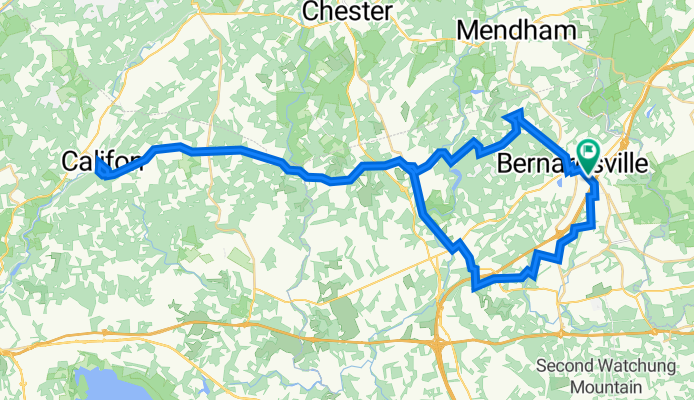
Califon - out and back
A cycling route starting in Bernardsville, New Jersey, United States of America.
Overview
About this route
Califon - out and back
- -:--
- Duration
- 65.3 km
- Distance
- 1,125 m
- Ascent
- 1,120 m
- Descent
- ---
- Avg. speed
- 261 m
- Avg. speed
Route quality
Waytypes & surfaces along the route
Waytypes
Busy road
37.3 km
(57 %)
Quiet road
16.5 km
(25 %)
Surfaces
Paved
13 km
(20 %)
Asphalt
12.9 km
(20 %)
Paved (undefined)
0.1 km
(<1 %)
Undefined
52.3 km
(80 %)
Continue with Bikemap
Use, edit, or download this cycling route
You would like to ride Califon - out and back or customize it for your own trip? Here is what you can do with this Bikemap route:
Free features
- Save this route as favorite or in collections
- Copy & plan your own version of this route
- Sync your route with Garmin or Wahoo
Premium features
Free trial for 3 days, or one-time payment. More about Bikemap Premium.
- Navigate this route on iOS & Android
- Export a GPX / KML file of this route
- Create your custom printout (try it for free)
- Download this route for offline navigation
Discover more Premium features.
Get Bikemap PremiumFrom our community
Other popular routes starting in Bernardsville
 Washington Corner Road 140, Bernardsville to Washington Corner Road 140, Bernardsville
- Distance
- 24.3 km
- Ascent
- 314 m
- Descent
- 319 m
- Location
- Bernardsville, New Jersey, United States of America
 Joanne 8/5/23
- Distance
- 40.9 km
- Ascent
- 661 m
- Descent
- 662 m
- Location
- Bernardsville, New Jersey, United States of America
 13 West St, Bernardsville to 11 West St, Bernardsville
- Distance
- 12.8 km
- Ascent
- 237 m
- Descent
- 232 m
- Location
- Bernardsville, New Jersey, United States of America
 Ridge-Bernardsville-Far Hills
- Distance
- 29.8 km
- Ascent
- 300 m
- Descent
- 300 m
- Location
- Bernardsville, New Jersey, United States of America
 55 mile
- Distance
- 87.4 km
- Ascent
- 1,358 m
- Descent
- 1,355 m
- Location
- Bernardsville, New Jersey, United States of America
 Mountain Route
- Distance
- 22.6 km
- Ascent
- 295 m
- Descent
- 295 m
- Location
- Bernardsville, New Jersey, United States of America
 55 S Maple Ave, Basking Ridge to Morristown
- Distance
- 13.8 km
- Ascent
- 108 m
- Descent
- 108 m
- Location
- Bernardsville, New Jersey, United States of America
 Tommy's first 20 mile ride
- Distance
- 36.2 km
- Ascent
- 186 m
- Descent
- 188 m
- Location
- Bernardsville, New Jersey, United States of America
Open it in the app