

my sist
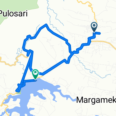
RJ62+VF9, Kecamatan Pangalengan to RH2P+CP5, Kecamatan Pangalengan
A cycling route starting in Santosa, West Java, Indonesia.
Overview
About this route
- 43 min
- Duration
- 4.8 km
- Distance
- 90 m
- Ascent
- 116 m
- Descent
- 6.7 km/h
- Avg. speed
- 1,521 m
- Max. altitude

Part of
my sist
1 stage
Route quality
Waytypes & surfaces along the route
Waytypes
Quiet road
2.7 km
(57 %)
Living street
0.1 km
(2 %)
Undefined
1.9 km
(41 %)
Surfaces
Paved
4.7 km
(98 %)
Asphalt
4.7 km
(98 %)
Undefined
0.1 km
(2 %)
Continue with Bikemap
Use, edit, or download this cycling route
You would like to ride RJ62+VF9, Kecamatan Pangalengan to RH2P+CP5, Kecamatan Pangalengan or customize it for your own trip? Here is what you can do with this Bikemap route:
Free features
- Save this route as favorite or in collections
- Copy & plan your own version of this route
- Sync your route with Garmin or Wahoo
Premium features
Free trial for 3 days, or one-time payment. More about Bikemap Premium.
- Navigate this route on iOS & Android
- Export a GPX / KML file of this route
- Create your custom printout (try it for free)
- Download this route for offline navigation
Discover more Premium features.
Get Bikemap PremiumFrom our community
Other popular routes starting in Santosa
 RJ62+VF9, Kecamatan Pangalengan to RH2P+CP5, Kecamatan Pangalengan
- Distance
- 4.8 km
- Ascent
- 90 m
- Descent
- 116 m
- Location
- Santosa, West Java, Indonesia
 Wayang Windu
- Distance
- 25.8 km
- Ascent
- 603 m
- Descent
- 546 m
- Location
- Santosa, West Java, Indonesia
 Wayang Windu (edit)
- Distance
- 11.1 km
- Ascent
- 504 m
- Descent
- 197 m
- Location
- Santosa, West Java, Indonesia
 PAB Kertamanah - Situ Cileunca
- Distance
- 14.2 km
- Ascent
- 145 m
- Descent
- 468 m
- Location
- Santosa, West Java, Indonesia
 Touring bareng rsud soreang
- Distance
- 18.4 km
- Ascent
- 505 m
- Descent
- 467 m
- Location
- Santosa, West Java, Indonesia
 Pine Garden Wayang Windu, Kecamatan Pangalengan to Pine Garden Wayang Windu, Kecamatan Pangalengan
- Distance
- 6.1 km
- Ascent
- 95 m
- Descent
- 91 m
- Location
- Santosa, West Java, Indonesia
 Sedep to Gn. Kendang Tegalpanjang
- Distance
- 24 km
- Ascent
- 726 m
- Descent
- 725 m
- Location
- Santosa, West Java, Indonesia
 Route CikarangMTB KOLOZAL #12
- Distance
- 28.1 km
- Ascent
- 575 m
- Descent
- 606 m
- Location
- Santosa, West Java, Indonesia
Open it in the app