

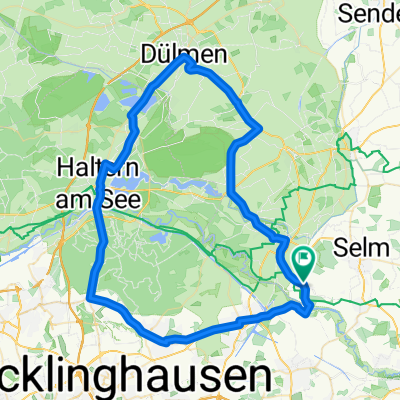
Ab Brückenstr. nach Horneburg, zurück nach Am Mühlenbach
A cycling route starting in Datteln, North Rhine-Westphalia, Germany.
Overview
About this route
From Brückenstr. to Horneburg, back to Am Mühlenbach
- -:--
- Duration
- 20.4 km
- Distance
- 77 m
- Ascent
- 74 m
- Descent
- ---
- Avg. speed
- 78 m
- Max. altitude

Route quality
Waytypes & surfaces along the route
Waytypes
Quiet road
12.7 km
(62 %)
Track
1.8 km
(9 %)
Surfaces
Paved
7.8 km
(38 %)
Unpaved
1.6 km
(8 %)
Asphalt
6.9 km
(34 %)
Gravel
0.8 km
(4 %)
Continue with Bikemap
Use, edit, or download this cycling route
You would like to ride Ab Brückenstr. nach Horneburg, zurück nach Am Mühlenbach or customize it for your own trip? Here is what you can do with this Bikemap route:
Free features
- Save this route as favorite or in collections
- Copy & plan your own version of this route
- Sync your route with Garmin or Wahoo
Premium features
Free trial for 3 days, or one-time payment. More about Bikemap Premium.
- Navigate this route on iOS & Android
- Export a GPX / KML file of this route
- Create your custom printout (try it for free)
- Download this route for offline navigation
Discover more Premium features.
Get Bikemap PremiumFrom our community
Other popular routes starting in Datteln
 Rundfahrt Mutter Althoff 36km
- Distance
- 36.5 km
- Ascent
- 83 m
- Descent
- 79 m
- Location
- Datteln, North Rhine-Westphalia, Germany
 Datteln-Haltern am See-Dülmen-Seppentade-Olfen
- Distance
- 63.6 km
- Ascent
- 241 m
- Descent
- 243 m
- Location
- Datteln, North Rhine-Westphalia, Germany
 GPX Download: Steveraue – Haus Visbeck Runde von Olfen
- Distance
- 51.5 km
- Ascent
- 202 m
- Descent
- 201 m
- Location
- Datteln, North Rhine-Westphalia, Germany
 GPX Download: Blick auf Schloss Nordkirchen – Radweg an der Stever Runde von Olfen
- Distance
- 57.1 km
- Ascent
- 206 m
- Descent
- 206 m
- Location
- Datteln, North Rhine-Westphalia, Germany
 Olfen - Hof Lünemann Cappenberg
- Distance
- 29.2 km
- Ascent
- 206 m
- Descent
- 208 m
- Location
- Datteln, North Rhine-Westphalia, Germany
 Rundkurs Haltern
- Distance
- 66.1 km
- Ascent
- 251 m
- Descent
- 267 m
- Location
- Datteln, North Rhine-Westphalia, Germany
 AR2_27-DattHafen-DHK-Waltr-Bork-Vinnum-Sülsen-AlteFahrt-Datt
- Distance
- 27.4 km
- Ascent
- 38 m
- Descent
- 30 m
- Location
- Datteln, North Rhine-Westphalia, Germany
 GPX Download: Ternscher See – Alte Zechenbahntrasse Runde von Olfen
- Distance
- 52.1 km
- Ascent
- 198 m
- Descent
- 198 m
- Location
- Datteln, North Rhine-Westphalia, Germany
Open it in the app