

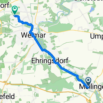
Weimar/Taubach - Ilm-Saale-Platte und zurück
A cycling route starting in Mellingen, Free State of Thuringia, Germany.
Overview
About this route
25km befestigte Radwege, 20km gut befestigte Wald- und Feldwege, 12km schwach befahrene untergeordnete Landstraße. Von Weimar/Taubach über Mellingen, Forellengrund Killiansroda hinauf nach Linda an der Cattlemens Ranch vorbei über Maina, Pfingsttal zur Einkehrmöglichkeit Waldgasthaus Müllershausen. Weiter über Blankenhain, Rottdorf, Altdörnfeld hinauf aufs Plateau nach Hochdorf, Haufeld, Treppendorf und Rittersdorf dann wieder hinab ins Ilmtal nach Tannroda. Hier lockt die Eisdiele zu erster Belohnung. Weiter dann auf dem Ilmradweg nach Bad Berka ( Einkehrmöglichkeit Eisdiele oder Altes Brauhaus im Zentrum, weiter über Hetschburg ( Einkehrmöglichkeit im Gasthaus ) Buchfart ( Mühle, historische überdachte Holzbrücke, Mühlencafe ) und Oettern ( Einkehr auf dem Campingplatz möglich ) zurück nach Weimar. Entspannend für E-Bike, ambitioniert für Nichtelektrische auf Mountainbike oder Trekking-Rad.
- -:--
- Duration
- 57.3 km
- Distance
- 784 m
- Ascent
- 773 m
- Descent
- ---
- Avg. speed
- 476 m
- Avg. speed
Route photos


Route quality
Waytypes & surfaces along the route
Waytypes
Track
19.9 km
(35 %)
Quiet road
13.2 km
(23 %)
Surfaces
Paved
40.1 km
(70 %)
Unpaved
10.1 km
(18 %)
Asphalt
38.7 km
(67 %)
Gravel
7.8 km
(14 %)
Continue with Bikemap
Use, edit, or download this cycling route
You would like to ride Weimar/Taubach - Ilm-Saale-Platte und zurück or customize it for your own trip? Here is what you can do with this Bikemap route:
Free features
- Save this route as favorite or in collections
- Copy & plan your own version of this route
- Sync your route with Garmin or Wahoo
Premium features
Free trial for 3 days, or one-time payment. More about Bikemap Premium.
- Navigate this route on iOS & Android
- Export a GPX / KML file of this route
- Create your custom printout (try it for free)
- Download this route for offline navigation
Discover more Premium features.
Get Bikemap PremiumFrom our community
Other popular routes starting in Mellingen
 Zickzack Tour
- Distance
- 101.2 km
- Ascent
- 830 m
- Descent
- 830 m
- Location
- Mellingen, Free State of Thuringia, Germany
 2024-07-14: Ilm-Saale-Raddreieck
- Distance
- 91.8 km
- Ascent
- 615 m
- Descent
- 614 m
- Location
- Mellingen, Free State of Thuringia, Germany
 Straße am Orte 152A, Mellingen do Moskauer Straße 126, Weimar
- Distance
- 9.6 km
- Ascent
- 56 m
- Descent
- 36 m
- Location
- Mellingen, Free State of Thuringia, Germany
 Nebra Tour
- Distance
- 135.8 km
- Ascent
- 1,049 m
- Descent
- 1,049 m
- Location
- Mellingen, Free State of Thuringia, Germany
 Rhön und Thüringer Wald
- Distance
- 206.9 km
- Ascent
- 1,229 m
- Descent
- 1,234 m
- Location
- Mellingen, Free State of Thuringia, Germany
 we Planung KW33
- Distance
- 69.5 km
- Ascent
- 866 m
- Descent
- 866 m
- Location
- Mellingen, Free State of Thuringia, Germany
 Weimar - Naumburg II
- Distance
- 60.7 km
- Ascent
- 279 m
- Descent
- 406 m
- Location
- Mellingen, Free State of Thuringia, Germany
 Alltagsrunde
- Distance
- 57.7 km
- Ascent
- 313 m
- Descent
- 313 m
- Location
- Mellingen, Free State of Thuringia, Germany
Open it in the app