
#Brenner-Reschenpass-Rosenheim-4#
A cycling route starting in Stams, Tyrol, Austria.
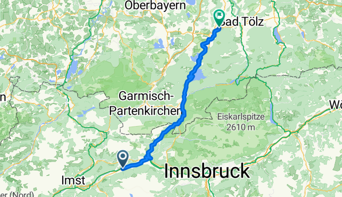
Overview
About this route
fällig im Mai 2012!
- -:--
- Duration
- 88.5 km
- Distance
- 877 m
- Ascent
- 840 m
- Descent
- ---
- Avg. speed
- ---
- Avg. speed
Continue with Bikemap
Use, edit, or download this cycling route
You would like to ride #Brenner-Reschenpass-Rosenheim-4# or customize it for your own trip? Here is what you can do with this Bikemap route:
Free features
- Save this route as favorite or in collections
- Copy & plan your own version of this route
- Sync your route with Garmin or Wahoo
Premium features
Free trial for 3 days, or one-time payment. More about Bikemap Premium.
- Navigate this route on iOS & Android
- Export a GPX / KML file of this route
- Create your custom printout (try it for free)
- Download this route for offline navigation
Discover more Premium features.
Get Bikemap PremiumFrom our community
Other popular routes starting in Stams
 2014-Mo
- Distance
- 147 km
- Ascent
- 772 m
- Descent
- 959 m
- Location
- Stams, Tyrol, Austria
 0802_kühtai_telfs
- Distance
- 39.2 km
- Ascent
- 79 m
- Descent
- 1,481 m
- Location
- Stams, Tyrol, Austria
 Ötztalrunde2011 Teil2
- Distance
- 127.2 km
- Ascent
- 2,893 m
- Descent
- 4,150 m
- Location
- Stams, Tyrol, Austria
 Kuehtai - St. Leonhard
- Distance
- 122.8 km
- Ascent
- 1,950 m
- Descent
- 3,217 m
- Location
- Stams, Tyrol, Austria
 2014-Mo
- Distance
- 145.2 km
- Ascent
- 733 m
- Descent
- 920 m
- Location
- Stams, Tyrol, Austria
 Venedig - Lohmar 2019 6
- Distance
- 62.9 km
- Ascent
- 779 m
- Descent
- 443 m
- Location
- Stams, Tyrol, Austria
 Stams-München
- Distance
- 138.3 km
- Ascent
- 780 m
- Descent
- 882 m
- Location
- Stams, Tyrol, Austria
 mit zeiftahren zum englischen Garten
- Distance
- 155.9 km
- Ascent
- 880 m
- Descent
- 1,011 m
- Location
- Stams, Tyrol, Austria
Open it in the app