
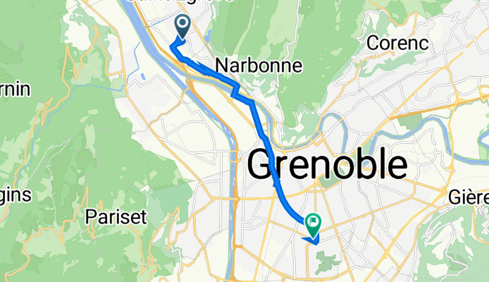
5 Rue Mélusine, Saint-Égrève à 2 Rue des Alliés, Grenoble
A cycling route starting in Saint Egreve, Auvergne-Rhône-Alpes, France.
Overview
About this route
- 32 min
- Duration
- 8.6 km
- Distance
- 35 m
- Ascent
- 21 m
- Descent
- 16.4 km/h
- Avg. speed
- 224 m
- Avg. speed
Route quality
Waytypes & surfaces along the route
Waytypes
Cycleway
7.4 km
(86 %)
Path
0.7 km
(9 %)
Surfaces
Paved
7.8 km
(91 %)
Asphalt
7.4 km
(86 %)
Paved (undefined)
0.3 km
(3 %)
Continue with Bikemap
Use, edit, or download this cycling route
You would like to ride 5 Rue Mélusine, Saint-Égrève à 2 Rue des Alliés, Grenoble or customize it for your own trip? Here is what you can do with this Bikemap route:
Free features
- Save this route as favorite or in collections
- Copy & plan your own version of this route
- Sync your route with Garmin or Wahoo
Premium features
Free trial for 3 days, or one-time payment. More about Bikemap Premium.
- Navigate this route on iOS & Android
- Export a GPX / KML file of this route
- Create your custom printout (try it for free)
- Download this route for offline navigation
Discover more Premium features.
Get Bikemap PremiumFrom our community
Other popular routes starting in Saint Egreve
 Ascension des Cols de PALAQUIT-PORTE-VENCE et Clémencières
- Distance
- 44.9 km
- Ascent
- 1,261 m
- Descent
- 1,249 m
- Location
- Saint Egreve, Auvergne-Rhône-Alpes, France
 st Egreve Joncquiere v3
- Distance
- 273.1 km
- Ascent
- 2,760 m
- Descent
- 2,970 m
- Location
- Saint Egreve, Auvergne-Rhône-Alpes, France
 CduSoleil tronc. I-22a
- Distance
- 9.4 km
- Ascent
- 43 m
- Descent
- 49 m
- Location
- Saint Egreve, Auvergne-Rhône-Alpes, France
 tims warners
- Distance
- 9.7 km
- Ascent
- 89 m
- Descent
- 60 m
- Location
- Saint Egreve, Auvergne-Rhône-Alpes, France
 ST EGREVE/PUGET-THENIERS
- Distance
- 278.7 km
- Ascent
- 3,055 m
- Descent
- 2,855 m
- Location
- Saint Egreve, Auvergne-Rhône-Alpes, France
 Tour de Quaix en Chartreuse - 3743 - UtagawaVTT.com
- Distance
- 16.4 km
- Ascent
- 546 m
- Descent
- 545 m
- Location
- Saint Egreve, Auvergne-Rhône-Alpes, France
 gorges 2
- Distance
- 115.9 km
- Ascent
- 2,472 m
- Descent
- 2,489 m
- Location
- Saint Egreve, Auvergne-Rhône-Alpes, France
 Alpentocht 2015 Dag 3 kort Grenoble - Chamberry
- Distance
- 119 km
- Ascent
- 2,477 m
- Descent
- 2,455 m
- Location
- Saint Egreve, Auvergne-Rhône-Alpes, France
Open it in the app