
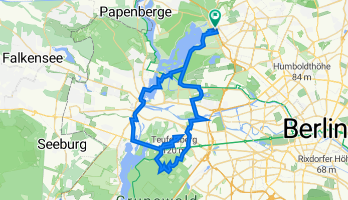
Tegel 11, 41 Km - Olympiastadion via Teufelsberg
A cycling route starting in Tegel, Land Berlin, Germany.
Overview
About this route
- Es gibt einige Treppenstufen im Waldabschnitt dem Quellenweg entlang, aber nichts Böses (!); 2) Zugang zur Anlage auf dem Teufelsberg ist gesperrt. Öffnungszeiten und Eintrittsgeld: www.teufelsberg-berlin.de; 3) Die Waldbühne befindet sich in der Nähe des Stadions
- 3 h 28 min
- Duration
- 41.3 km
- Distance
- 240 m
- Ascent
- 241 m
- Descent
- 11.9 km/h
- Avg. speed
- 102 m
- Avg. speed

Route photos


Route quality
Waytypes & surfaces along the route
Waytypes
Quiet road
9.9 km
(24 %)
Road
7.8 km
(19 %)
Surfaces
Paved
33.8 km
(82 %)
Unpaved
4.6 km
(11 %)
Asphalt
29.3 km
(71 %)
Paving stones
4.5 km
(11 %)
Continue with Bikemap
Use, edit, or download this cycling route
You would like to ride Tegel 11, 41 Km - Olympiastadion via Teufelsberg or customize it for your own trip? Here is what you can do with this Bikemap route:
Free features
- Save this route as favorite or in collections
- Copy & plan your own version of this route
- Sync your route with Garmin or Wahoo
Premium features
Free trial for 3 days, or one-time payment. More about Bikemap Premium.
- Navigate this route on iOS & Android
- Export a GPX / KML file of this route
- Create your custom printout (try it for free)
- Download this route for offline navigation
Discover more Premium features.
Get Bikemap PremiumFrom our community
Other popular routes starting in Tegel
 Tegel 6, viel Wald und ein Stück Mauerweg
- Distance
- 31.1 km
- Ascent
- 169 m
- Descent
- 166 m
- Location
- Tegel, Land Berlin, Germany
 Tegel 10, 48 Km - eine Fahrt im Schatten
- Distance
- 47.6 km
- Ascent
- 227 m
- Descent
- 224 m
- Location
- Tegel, Land Berlin, Germany
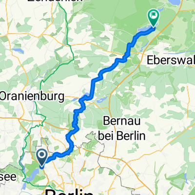
 MTB Tour: Tegel > Eberswalde modified Tegel>Werbellinsee
- Distance
- 97.2 km
- Ascent
- 201 m
- Descent
- 199 m
- Location
- Tegel, Land Berlin, Germany
 Tegel 5, Rad und Geschichte
- Distance
- 22.2 km
- Ascent
- 84 m
- Descent
- 84 m
- Location
- Tegel, Land Berlin, Germany
 BAT Tegel, Siemensstadt, Havelchaussee, Spandau, Henningsdorf
- Distance
- 54 km
- Ascent
- 194 m
- Descent
- 193 m
- Location
- Tegel, Land Berlin, Germany
 Freienhagen
- Distance
- 89.2 km
- Ascent
- 128 m
- Descent
- 128 m
- Location
- Tegel, Land Berlin, Germany
 2009 Sonntagstour Tegel ->Nordwärts Landstrasse
- Distance
- 74.9 km
- Ascent
- 148 m
- Descent
- 153 m
- Location
- Tegel, Land Berlin, Germany
 MTB Tour: Tegel > Werbellinsee
- Distance
- 64.8 km
- Ascent
- 167 m
- Descent
- 148 m
- Location
- Tegel, Land Berlin, Germany
Open it in the app