
Goriška cesta 8 to Goriška cesta 10
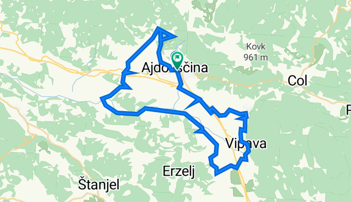
A cycling route starting in Ajdovščina, Občina Ajdovščina, Slovenia.
Overview
About this route
- 3 h 43 min
- Duration
- 39.1 km
- Distance
- 591 m
- Ascent
- 594 m
- Descent
- 10.5 km/h
- Avg. speed
- 239 m
- Avg. speed

Route quality
Waytypes & surfaces along the route
Waytypes
Quiet road
21.4 km
(55 %)
Track
8.9 km
(23 %)
Surfaces
Paved
19.9 km
(51 %)
Unpaved
12.1 km
(31 %)
Asphalt
19.9 km
(51 %)
Gravel
9.9 km
(25 %)
Continue with Bikemap
Use, edit, or download this cycling route
You would like to ride Goriška cesta 8 to Goriška cesta 10 or customize it for your own trip? Here is what you can do with this Bikemap route:
Free features
- Save this route as favorite or in collections
- Copy & plan your own version of this route
- Sync your route with Garmin or Wahoo
Premium features
Free trial for 3 days, or one-time payment. More about Bikemap Premium.
- Navigate this route on iOS & Android
- Export a GPX / KML file of this route
- Create your custom printout (try it for free)
- Download this route for offline navigation
Discover more Premium features.
Get Bikemap PremiumFrom our community
Other popular routes starting in Ajdovščina
 Idrija 1
- Distance
- 78.3 km
- Ascent
- 1,856 m
- Descent
- 1,859 m
- Location
- Ajdovščina, Občina Ajdovščina, Slovenia
 Ajdovska runda
- Distance
- 59.1 km
- Ascent
- 351 m
- Descent
- 351 m
- Location
- Ajdovščina, Občina Ajdovščina, Slovenia
 Rally Saturnus MTB
- Distance
- 65.7 km
- Ascent
- 1,197 m
- Descent
- 1,204 m
- Location
- Ajdovščina, Občina Ajdovščina, Slovenia
 Vipavski Kriz and around
- Distance
- 42.7 km
- Ascent
- 934 m
- Descent
- 934 m
- Location
- Ajdovščina, Občina Ajdovščina, Slovenia
 Ajdovščina - Podnanos - Eko koča - Abram - Ajdovščina
- Distance
- 50.9 km
- Ascent
- 1,080 m
- Descent
- 1,081 m
- Location
- Ajdovščina, Občina Ajdovščina, Slovenia
 Ajdovščina - Predmeja - Čaven - Col - Ajdovščina
- Distance
- 48.3 km
- Ascent
- 1,281 m
- Descent
- 1,281 m
- Location
- Ajdovščina, Občina Ajdovščina, Slovenia
 Ajdovščina-Pruft-Lokavec-Ajdovščina
- Distance
- 17.4 km
- Ascent
- 657 m
- Descent
- 657 m
- Location
- Ajdovščina, Občina Ajdovščina, Slovenia
 from Ajdovščina to our campsite 😊
- Distance
- 26.3 km
- Ascent
- 1,028 m
- Descent
- 789 m
- Location
- Ajdovščina, Občina Ajdovščina, Slovenia
Open it in the app