
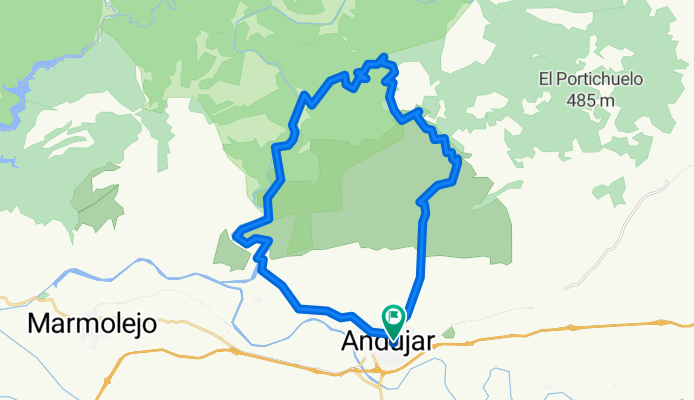
Andújar-La Cadena- Los tuneles-Andújar.
A cycling route starting in Andújar, Andalusia, Spain.
Overview
About this route
Subida por La Cadena, continuamos por el camino viejo pasando el mirador del peregrino y tras bajar al camino de la carretas giramos en el cruce a izquierdas. Bajamos hasta el río Jándula, pasando por el salto del arroyo el Gallo. Siguiendo el río pasamos por un tunel de la antigua vía del ferrocarril y de ahí a la Ropera y vuelta a casa.
- -:--
- Duration
- 36.3 km
- Distance
- 554 m
- Ascent
- 557 m
- Descent
- ---
- Avg. speed
- ---
- Avg. speed

Continue with Bikemap
Use, edit, or download this cycling route
You would like to ride Andújar-La Cadena- Los tuneles-Andújar. or customize it for your own trip? Here is what you can do with this Bikemap route:
Free features
- Save this route as favorite or in collections
- Copy & plan your own version of this route
- Sync your route with Garmin or Wahoo
Premium features
Free trial for 3 days, or one-time payment. More about Bikemap Premium.
- Navigate this route on iOS & Android
- Export a GPX / KML file of this route
- Create your custom printout (try it for free)
- Download this route for offline navigation
Discover more Premium features.
Get Bikemap PremiumFrom our community
Other popular routes starting in Andújar
 7. Andújar-Alcalá la Real
- Distance
- 118.1 km
- Ascent
- 2,305 m
- Descent
- 1,591 m
- Location
- Andújar, Andalusia, Spain
 La Parrilla - Alcaparrosa - Capellanías
- Distance
- 33.6 km
- Ascent
- 467 m
- Descent
- 467 m
- Location
- Andújar, Andalusia, Spain
 Andujar (subida al santuario)
- Distance
- 65.5 km
- Ascent
- 955 m
- Descent
- 955 m
- Location
- Andújar, Andalusia, Spain
 Andújar-Gorgogil-Los Villares
- Distance
- 48.5 km
- Ascent
- 297 m
- Descent
- 297 m
- Location
- Andújar, Andalusia, Spain
 La Cadena, -Sendero Miguelón-Peregrino-Los Caballos
- Distance
- 30.3 km
- Ascent
- 577 m
- Descent
- 577 m
- Location
- Andújar, Andalusia, Spain
 Sierra Andujar-Sta Maria Cabeza (ida-vuelta)
- Distance
- 98.4 km
- Ascent
- 1,140 m
- Descent
- 1,139 m
- Location
- Andújar, Andalusia, Spain
 Andújar-Río Jándula-Andújar
- Distance
- 44.8 km
- Ascent
- 611 m
- Descent
- 610 m
- Location
- Andújar, Andalusia, Spain
 Andújar-La Parrilla-Capellanías-Andújar
- Distance
- 33.8 km
- Ascent
- 476 m
- Descent
- 478 m
- Location
- Andújar, Andalusia, Spain
Open it in the app