

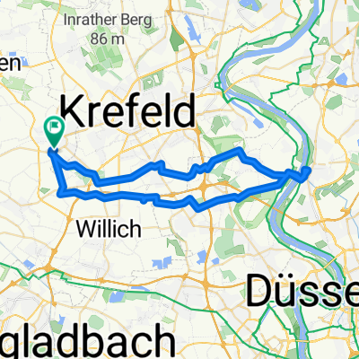
Weberstraße 24, Tönisvorst nach Weberstraße 24, Tönisvorst
A cycling route starting in Tönisvorst, North Rhine-Westphalia, Germany.
Overview
About this route
- 7 h 8 min
- Duration
- 86.7 km
- Distance
- 152 m
- Ascent
- 198 m
- Descent
- 12.2 km/h
- Avg. speed
- 84 m
- Avg. speed

Continue with Bikemap
Use, edit, or download this cycling route
You would like to ride Weberstraße 24, Tönisvorst nach Weberstraße 24, Tönisvorst or customize it for your own trip? Here is what you can do with this Bikemap route:
Free features
- Save this route as favorite or in collections
- Copy & plan your own version of this route
- Sync your route with Garmin or Wahoo
Premium features
Free trial for 3 days, or one-time payment. More about Bikemap Premium.
- Navigate this route on iOS & Android
- Export a GPX / KML file of this route
- Create your custom printout (try it for free)
- Download this route for offline navigation
Discover more Premium features.
Get Bikemap PremiumFrom our community
Other popular routes starting in Tönisvorst
 Kleiner und Großer De Wittsee – Bahntrasse Runde von Forsthaus
- Distance
- 64.3 km
- Ascent
- 122 m
- Descent
- 125 m
- Location
- Tönisvorst, North Rhine-Westphalia, Germany
 Niederrhein-3
- Distance
- 46.7 km
- Ascent
- 58 m
- Descent
- 57 m
- Location
- Tönisvorst, North Rhine-Westphalia, Germany
 Von St.Tönis über Kaldenkirchen und zurück
- Distance
- 68.7 km
- Ascent
- 115 m
- Descent
- 119 m
- Location
- Tönisvorst, North Rhine-Westphalia, Germany
 Staubwolke Fischeln 09 Sommertraining
- Distance
- 57.8 km
- Ascent
- 55 m
- Descent
- 60 m
- Location
- Tönisvorst, North Rhine-Westphalia, Germany
 Rund um Hüls
- Distance
- 24 km
- Ascent
- 53 m
- Descent
- 53 m
- Location
- Tönisvorst, North Rhine-Westphalia, Germany
 Tönisvorst - Nordbahnhof - Stadtwald - Großmarkt - Tönisvorst
- Distance
- 23.3 km
- Ascent
- 21 m
- Descent
- 19 m
- Location
- Tönisvorst, North Rhine-Westphalia, Germany
 Niederrhein-2
- Distance
- 29.4 km
- Ascent
- 9 m
- Descent
- 9 m
- Location
- Tönisvorst, North Rhine-Westphalia, Germany
 Anrath-Vorst-Kempen-Grefrath-Süchteln
- Distance
- 49 km
- Ascent
- 27 m
- Descent
- 29 m
- Location
- Tönisvorst, North Rhine-Westphalia, Germany
Open it in the app