
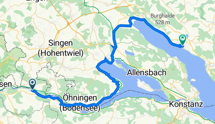
Ueberlingen
A cycling route starting in Diessenhofen, Thurgau, Switzerland.
Overview
About this route
über Moos - Bodmann
- -:--
- Duration
- 61.4 km
- Distance
- 550 m
- Ascent
- 533 m
- Descent
- ---
- Avg. speed
- 472 m
- Avg. speed
Route quality
Waytypes & surfaces along the route
Waytypes
Path
27.8 km
(45 %)
Quiet road
16.2 km
(26 %)
Surfaces
Paved
59.8 km
(97 %)
Unpaved
0 km
(<1 %)
Asphalt
58.6 km
(95 %)
Paved (undefined)
1 km
(2 %)
Continue with Bikemap
Use, edit, or download this cycling route
You would like to ride Ueberlingen or customize it for your own trip? Here is what you can do with this Bikemap route:
Free features
- Save this route as favorite or in collections
- Copy & plan your own version of this route
- Sync your route with Garmin or Wahoo
Premium features
Free trial for 3 days, or one-time payment. More about Bikemap Premium.
- Navigate this route on iOS & Android
- Export a GPX / KML file of this route
- Create your custom printout (try it for free)
- Download this route for offline navigation
Discover more Premium features.
Get Bikemap PremiumFrom our community
Other popular routes starting in Diessenhofen
 Blickweg
- Distance
- 20.1 km
- Ascent
- 338 m
- Descent
- 337 m
- Location
- Diessenhofen, Thurgau, Switzerland
 Die einfache Runde
- Distance
- 47.4 km
- Ascent
- 214 m
- Descent
- 210 m
- Location
- Diessenhofen, Thurgau, Switzerland
 Ramsenerblickweg
- Distance
- 16.9 km
- Ascent
- 325 m
- Descent
- 325 m
- Location
- Diessenhofen, Thurgau, Switzerland
 Diessenhofen - Schlattingen
- Distance
- 17.1 km
- Ascent
- 285 m
- Descent
- 282 m
- Location
- Diessenhofen, Thurgau, Switzerland
 Geissenbach - Stein am Rhein
- Distance
- 27.2 km
- Ascent
- 197 m
- Descent
- 188 m
- Location
- Diessenhofen, Thurgau, Switzerland
 Tri Schaffhausen Kurzdistanz 31.3km
- Distance
- 31.3 km
- Ascent
- 390 m
- Descent
- 390 m
- Location
- Diessenhofen, Thurgau, Switzerland
 Diessenhofen-Ramsener Blick
- Distance
- 22.8 km
- Ascent
- 569 m
- Descent
- 574 m
- Location
- Diessenhofen, Thurgau, Switzerland
 Rundtour über Rodenberg -Schienerberg - Hohenklingen
- Distance
- 45.8 km
- Ascent
- 1,010 m
- Descent
- 1,014 m
- Location
- Diessenhofen, Thurgau, Switzerland
Open it in the app