

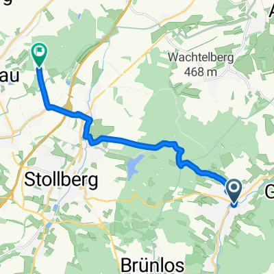
Berghausweg, Thalheim/Erzgeb. nach Hauptstraße 38, Pöhl
A cycling route starting in Thalheim, Saxony, Germany.
Overview
About this route
- 9 h 57 min
- Duration
- 82.2 km
- Distance
- 1,003 m
- Ascent
- 1,088 m
- Descent
- 8.3 km/h
- Avg. speed
- 567 m
- Avg. speed

Route photos


Route quality
Waytypes & surfaces along the route
Waytypes
Road
27.6 km
(34 %)
Quiet road
21.1 km
(26 %)
Surfaces
Paved
56 km
(68 %)
Unpaved
1.7 km
(2 %)
Asphalt
51 km
(62 %)
Paved (undefined)
2.6 km
(3 %)
Continue with Bikemap
Use, edit, or download this cycling route
You would like to ride Berghausweg, Thalheim/Erzgeb. nach Hauptstraße 38, Pöhl or customize it for your own trip? Here is what you can do with this Bikemap route:
Free features
- Save this route as favorite or in collections
- Copy & plan your own version of this route
- Sync your route with Garmin or Wahoo
Premium features
Free trial for 3 days, or one-time payment. More about Bikemap Premium.
- Navigate this route on iOS & Android
- Export a GPX / KML file of this route
- Create your custom printout (try it for free)
- Download this route for offline navigation
Discover more Premium features.
Get Bikemap PremiumFrom our community
Other popular routes starting in Thalheim
 bikeroute to tirana
- Distance
- 1,963.8 km
- Ascent
- 5,127 m
- Descent
- 5,480 m
- Location
- Thalheim, Saxony, Germany
 Berghausweg, Thalheim/Erzgeb. nach Hauptstraße 38, Pöhl
- Distance
- 82.2 km
- Ascent
- 1,003 m
- Descent
- 1,088 m
- Location
- Thalheim, Saxony, Germany
 Uferstraße 11, Thalheim/Erzgeb. nach Uferstraße 11, Thalheim/Erzgeb.
- Distance
- 21.8 km
- Ascent
- 435 m
- Descent
- 481 m
- Location
- Thalheim, Saxony, Germany
 alte Ziegelei
- Distance
- 9.4 km
- Ascent
- 136 m
- Descent
- 190 m
- Location
- Thalheim, Saxony, Germany
 Thalheim_Chemnitz
- Distance
- 21 km
- Ascent
- 252 m
- Descent
- 380 m
- Location
- Thalheim, Saxony, Germany
 Thalheim Aue
- Distance
- 23.4 km
- Ascent
- 139 m
- Descent
- 248 m
- Location
- Thalheim, Saxony, Germany
 Tabakstanne Talsperre kurz
- Distance
- 13.2 km
- Ascent
- 262 m
- Descent
- 264 m
- Location
- Thalheim, Saxony, Germany
 Rund um Thalheim
- Distance
- 15.2 km
- Ascent
- 308 m
- Descent
- 309 m
- Location
- Thalheim, Saxony, Germany
Open it in the app