

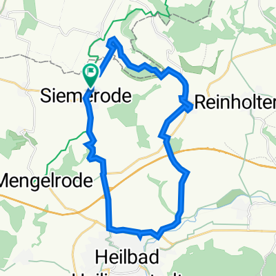
Weißenbörner Straße 115, Hohes Kreuz nach Weißenbörner Straße 115, Hohes Kreuz
A cycling route starting in Siemerode, Free State of Thuringia, Germany.
Overview
About this route
- 50 min
- Duration
- 18.2 km
- Distance
- 207 m
- Ascent
- 256 m
- Descent
- 21.7 km/h
- Avg. speed
- 369 m
- Avg. speed

Route quality
Waytypes & surfaces along the route
Waytypes
Track
6.9 km
(38 %)
Busy road
5.8 km
(32 %)
Surfaces
Paved
11.9 km
(65 %)
Unpaved
3.5 km
(19 %)
Asphalt
11.4 km
(63 %)
Gravel
1.7 km
(9 %)
Continue with Bikemap
Use, edit, or download this cycling route
You would like to ride Weißenbörner Straße 115, Hohes Kreuz nach Weißenbörner Straße 115, Hohes Kreuz or customize it for your own trip? Here is what you can do with this Bikemap route:
Free features
- Save this route as favorite or in collections
- Copy & plan your own version of this route
- Sync your route with Garmin or Wahoo
Premium features
Free trial for 3 days, or one-time payment. More about Bikemap Premium.
- Navigate this route on iOS & Android
- Export a GPX / KML file of this route
- Create your custom printout (try it for free)
- Download this route for offline navigation
Discover more Premium features.
Get Bikemap PremiumFrom our community
Other popular routes starting in Siemerode
 Weißenbörner Straße 115, Hohes Kreuz nach Weißenbörner Straße 115, Hohes Kreuz
- Distance
- 18.2 km
- Ascent
- 207 m
- Descent
- 256 m
- Location
- Siemerode, Free State of Thuringia, Germany
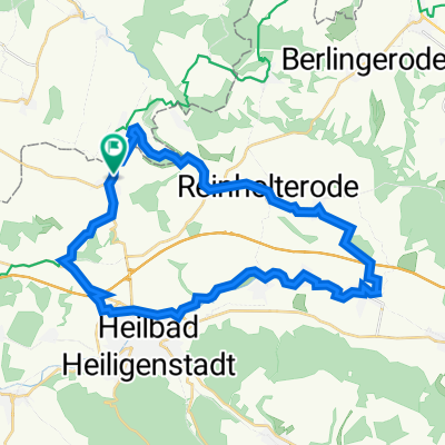
 Weißenbörner Straße 115, Hohes Kreuz nach Weißenbörner Straße 115, Hohes Kreuz
- Distance
- 11.7 km
- Ascent
- 110 m
- Descent
- 153 m
- Location
- Siemerode, Free State of Thuringia, Germany
 TL2020 Freitag RaceSpeed
- Distance
- 15.6 km
- Ascent
- 197 m
- Descent
- 194 m
- Location
- Siemerode, Free State of Thuringia, Germany
 Weißenbörner Straße 115, Hohes Kreuz nach Weißenbörner Straße 115, Hohes Kreuz
- Distance
- 10.6 km
- Ascent
- 126 m
- Descent
- 133 m
- Location
- Siemerode, Free State of Thuringia, Germany
 Streitholz 14, Hohes Kreuz nach L3080 12, Heilbad Heiligenstadt
- Distance
- 19.3 km
- Ascent
- 118 m
- Descent
- 250 m
- Location
- Siemerode, Free State of Thuringia, Germany
 Route von K119 110, Hohes Kreuz
- Distance
- 31.6 km
- Ascent
- 282 m
- Descent
- 335 m
- Location
- Siemerode, Free State of Thuringia, Germany
 Weißenbörner Straße 115, Hohes Kreuz nach Weißenbörner Straße 115, Hohes Kreuz
- Distance
- 25.2 km
- Ascent
- 194 m
- Descent
- 197 m
- Location
- Siemerode, Free State of Thuringia, Germany
 TL 2020 Abfahrt Freitag
- Distance
- 14.3 km
- Ascent
- 68 m
- Descent
- 158 m
- Location
- Siemerode, Free State of Thuringia, Germany
Open it in the app