

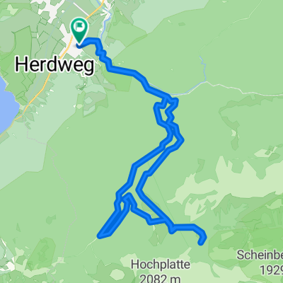
All10b: Trauchgau - Irsee 63,5km 610hm
A cycling route starting in Halblech, Bavaria, Germany.
Overview
About this route
Trauchgau - (BK Bodensee Königssee Radweg) - Unterreithen - Wies - (KBR Königlich Bayerische Radlrunde) - Litzau - Steingaden - (Schlosspark Runde) - Urspring - Ziegler - Burggen - (All Allgäu Runde) - Tannenberg - Ingenried - Frankenhofen - Helmishofen - Linden - Mauerstetten - Kaufbeuren - (ZR Zusam Radweg) - Ölmühlhang - Kleinkemnat - Irsee
Irseer Klosterbräu, Klosterring 1-3, 87660 Irsee
- 4 h 7 min
- Duration
- 63.5 km
- Distance
- 840 m
- Ascent
- 907 m
- Descent
- 15.4 km/h
- Avg. speed
- 890 m
- Avg. speed

Route quality
Waytypes & surfaces along the route
Waytypes
Quiet road
29.8 km
(47 %)
Path
15.7 km
(25 %)
Surfaces
Paved
49.2 km
(77 %)
Unpaved
4.1 km
(6 %)
Asphalt
48.8 km
(77 %)
Loose gravel
3.2 km
(5 %)
Continue with Bikemap
Use, edit, or download this cycling route
You would like to ride All10b: Trauchgau - Irsee 63,5km 610hm or customize it for your own trip? Here is what you can do with this Bikemap route:
Free features
- Save this route as favorite or in collections
- Copy & plan your own version of this route
- Sync your route with Garmin or Wahoo
Premium features
Free trial for 3 days, or one-time payment. More about Bikemap Premium.
- Navigate this route on iOS & Android
- Export a GPX / KML file of this route
- Create your custom printout (try it for free)
- Download this route for offline navigation
Discover more Premium features.
Get Bikemap PremiumFrom our community
Other popular routes starting in Halblech
 Roethenbachtal-Traúchberg
- Distance
- 67.3 km
- Ascent
- 2,412 m
- Descent
- 1,871 m
- Location
- Halblech, Bavaria, Germany
 D - Schlosspark - Panorama-Runde - 39 km
- Distance
- 38 km
- Ascent
- 482 m
- Descent
- 480 m
- Location
- Halblech, Bavaria, Germany
 Hallblech, Wieskirche um den hohen Traufberg
- Distance
- 42.5 km
- Ascent
- 565 m
- Descent
- 566 m
- Location
- Halblech, Bavaria, Germany
 Oberhalb der Kenzenhütte
- Distance
- 12.6 km
- Ascent
- 156 m
- Descent
- 901 m
- Location
- Halblech, Bavaria, Germany
 Kenzenhütte
- Distance
- 24.5 km
- Ascent
- 744 m
- Descent
- 744 m
- Location
- Halblech, Bavaria, Germany
 Von Halblech um den Hohen Trauchberg CLONED FROM ROUTE 34572
- Distance
- 36.6 km
- Ascent
- 826 m
- Descent
- 773 m
- Location
- Halblech, Bavaria, Germany
 Buching Kenzenhütte
- Distance
- 24.2 km
- Ascent
- 631 m
- Descent
- 637 m
- Location
- Halblech, Bavaria, Germany
 Ammertal MTB Runde
- Distance
- 33.1 km
- Ascent
- 469 m
- Descent
- 471 m
- Location
- Halblech, Bavaria, Germany
Open it in the app