

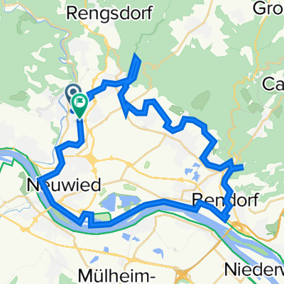
MTB-Runde: Biewer-Laub.-Mühle-Meinhof-Lauseich-Monrepos-Chr.-Hütte-Brombeer-Schaukel 33km 540Hm
A cycling route starting in Melsbach, Rhineland-Palatinate, Germany.
Overview
About this route
Laubachs Mühle, Anstieg zum Meinhof und Waldtrail zur
Lauseich-Hütte
Monrepos
dickster Nadelbaum im Kreis: Mammutbaum Monrepos
FriedWald Monrepos,
Mammut,
Jägerstuhlhütte
Christianhütte
Kappelhütte
Brombeerschänke, Panoramablick
Edmundhütte
eventl. Abstecher zur Weinbergschaukel
Schützenweg durch den Leutesdorfer Weinberg
Rheinstr. Leutesdorf
Ley’scher Hof
Feldkirchen
Aussichtspunkt Lindenbäumchen
Fliegerberg
Rodenbach
Niederbieber
- -:--
- Duration
- 33.2 km
- Distance
- 675 m
- Ascent
- 675 m
- Descent
- ---
- Avg. speed
- 361 m
- Avg. speed
Route quality
Waytypes & surfaces along the route
Waytypes
Track
19.2 km
(58 %)
Quiet road
9.3 km
(28 %)
Surfaces
Paved
16.8 km
(51 %)
Unpaved
15.1 km
(46 %)
Asphalt
10.2 km
(31 %)
Gravel
8.7 km
(26 %)
Continue with Bikemap
Use, edit, or download this cycling route
You would like to ride MTB-Runde: Biewer-Laub.-Mühle-Meinhof-Lauseich-Monrepos-Chr.-Hütte-Brombeer-Schaukel 33km 540Hm or customize it for your own trip? Here is what you can do with this Bikemap route:
Free features
- Save this route as favorite or in collections
- Copy & plan your own version of this route
- Sync your route with Garmin or Wahoo
Premium features
Free trial for 3 days, or one-time payment. More about Bikemap Premium.
- Navigate this route on iOS & Android
- Export a GPX / KML file of this route
- Create your custom printout (try it for free)
- Download this route for offline navigation
Discover more Premium features.
Get Bikemap PremiumFrom our community
Other popular routes starting in Melsbach
 Stausee_Zoo_Sayn_Bendorf_Engers_Deich 39km
- Distance
- 38.9 km
- Ascent
- 398 m
- Descent
- 369 m
- Location
- Melsbach, Rhineland-Palatinate, Germany
 Neuwieder Saisoneröffnung 2022 - RTF des Rad-Renn-Club Rhein-Wied Neuwied e.V. - 41 km Strecke
- Distance
- 41.6 km
- Ascent
- 328 m
- Descent
- 314 m
- Location
- Melsbach, Rhineland-Palatinate, Germany
 Hans-Müller-Tour, Schönes Wiedtal 2019 - RTF des Rad-Renn-Club Rhein-Wied Neuwied e.V. - 41 km Strecke
- Distance
- 35.7 km
- Ascent
- 515 m
- Descent
- 515 m
- Location
- Melsbach, Rhineland-Palatinate, Germany
 Hans-Müller-Tour, Schönes Wiedtal 2019 - RTF des Rad-Renn-Club Rhein-Wied Neuwied e.V. - 72 km Strecke
- Distance
- 67.8 km
- Ascent
- 238 m
- Descent
- 238 m
- Location
- Melsbach, Rhineland-Palatinate, Germany
 Neuwieder Saisoneröffnung 2022 - RTF des Rad-Renn-Club Rhein-Wied Neuwied e.V. - 117 km Strecke
- Distance
- 109.8 km
- Ascent
- 1,212 m
- Descent
- 1,199 m
- Location
- Melsbach, Rhineland-Palatinate, Germany
 Hans-Müller-Tour, Wiedtal 2013 - RTF des Rad-Renn-Club Rhein-Wied Neuwied e.V. - 71 km Strecke
- Distance
- 67.3 km
- Ascent
- 331 m
- Descent
- 331 m
- Location
- Melsbach, Rhineland-Palatinate, Germany
 Raiffeisen Permanente 2018 - 77 km Perm. des Rad-Renn-Club Rhein-Wied Neuwied e.V.
- Distance
- 78.8 km
- Ascent
- 786 m
- Descent
- 786 m
- Location
- Melsbach, Rhineland-Palatinate, Germany
 Aubachtal -> Hardert -> Melsbach
- Distance
- 20.5 km
- Ascent
- 378 m
- Descent
- 383 m
- Location
- Melsbach, Rhineland-Palatinate, Germany
Open it in the app