

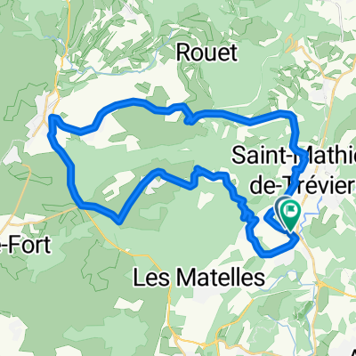
Pic St Lou
A cycling route starting in Saint-Mathieu-de-Tréviers, Occitanie, France.
Overview
About this route
- -:--
- Duration
- 36.3 km
- Distance
- 408 m
- Ascent
- 416 m
- Descent
- ---
- Avg. speed
- ---
- Max. altitude
Route quality
Waytypes & surfaces along the route
Waytypes
Busy road
17.8 km
(49 %)
Road
15.4 km
(42 %)
Surfaces
Paved
21 km
(58 %)
Unpaved
1 km
(3 %)
Asphalt
21 km
(58 %)
Ground
1 km
(3 %)
Continue with Bikemap
Use, edit, or download this cycling route
You would like to ride Pic St Lou or customize it for your own trip? Here is what you can do with this Bikemap route:
Free features
- Save this route as favorite or in collections
- Copy & plan your own version of this route
- Sync your route with Garmin or Wahoo
Premium features
Free trial for 3 days, or one-time payment. More about Bikemap Premium.
- Navigate this route on iOS & Android
- Export a GPX / KML file of this route
- Create your custom printout (try it for free)
- Download this route for offline navigation
Discover more Premium features.
Get Bikemap PremiumFrom our community
Other popular routes starting in Saint-Mathieu-de-Tréviers
 MUC 10-Parcours du 24/08/14
- Distance
- 102.5 km
- Ascent
- 1,252 m
- Descent
- 1,252 m
- Location
- Saint-Mathieu-de-Tréviers, Occitanie, France
 St-Mathieu de Treviers - Marseillette
- Distance
- 199.6 km
- Ascent
- 152 m
- Descent
- 172 m
- Location
- Saint-Mathieu-de-Tréviers, Occitanie, France
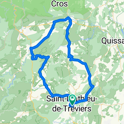
 valflaunés
- Distance
- 37.1 km
- Ascent
- 541 m
- Descent
- 542 m
- Location
- Saint-Mathieu-de-Tréviers, Occitanie, France
 Pic St Lou
- Distance
- 36.3 km
- Ascent
- 408 m
- Descent
- 416 m
- Location
- Saint-Mathieu-de-Tréviers, Occitanie, France
 MTB 22. Prades-le-Lez 40km
- Distance
- 31.8 km
- Ascent
- 369 m
- Descent
- 388 m
- Location
- Saint-Mathieu-de-Tréviers, Occitanie, France
 MTB 08. Autour de Saint Mathieu
- Distance
- 28.3 km
- Ascent
- 434 m
- Descent
- 431 m
- Location
- Saint-Mathieu-de-Tréviers, Occitanie, France
 Parcours N7
- Distance
- 76 km
- Ascent
- 654 m
- Descent
- 654 m
- Location
- Saint-Mathieu-de-Tréviers, Occitanie, France
 PIC SAINT LOUP PAR LA BUEGE
- Distance
- 77 km
- Ascent
- 967 m
- Descent
- 967 m
- Location
- Saint-Mathieu-de-Tréviers, Occitanie, France
Open it in the app