
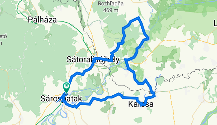
Sp-Pácin-Zemplén-Cséke-Sp
A cycling route starting in Sárospatak, Borsod-Abauj Zemplen county, Hungary.
Overview
About this route
- -:--
- Duration
- 80.6 km
- Distance
- 327 m
- Ascent
- 324 m
- Descent
- ---
- Avg. speed
- 258 m
- Avg. speed

Route quality
Waytypes & surfaces along the route
Waytypes
Road
36.3 km
(45 %)
Busy road
21.1 km
(26 %)
Surfaces
Paved
36.6 km
(45 %)
Unpaved
2.9 km
(4 %)
Asphalt
36.6 km
(45 %)
Ground
2.9 km
(4 %)
Undefined
41.2 km
(51 %)
Continue with Bikemap
Use, edit, or download this cycling route
You would like to ride Sp-Pácin-Zemplén-Cséke-Sp or customize it for your own trip? Here is what you can do with this Bikemap route:
Free features
- Save this route as favorite or in collections
- Copy & plan your own version of this route
- Sync your route with Garmin or Wahoo
Premium features
Free trial for 3 days, or one-time payment. More about Bikemap Premium.
- Navigate this route on iOS & Android
- Export a GPX / KML file of this route
- Create your custom printout (try it for free)
- Download this route for offline navigation
Discover more Premium features.
Get Bikemap PremiumFrom our community
Other popular routes starting in Sárospatak
 Sp-Kolóska-Újhuta-Hotyka-Sp
- Distance
- 43.1 km
- Ascent
- 663 m
- Descent
- 663 m
- Location
- Sárospatak, Borsod-Abauj Zemplen county, Hungary
 Patak-Pálháza-Gönc-Pálháza-Patak
- Distance
- 103.2 km
- Ascent
- 470 m
- Descent
- 470 m
- Location
- Sárospatak, Borsod-Abauj Zemplen county, Hungary
 Bringahorda 2017
- Distance
- 139.6 km
- Ascent
- 1,176 m
- Descent
- 1,176 m
- Location
- Sárospatak, Borsod-Abauj Zemplen county, Hungary
 Kerek kő 1.
- Distance
- 2.3 km
- Ascent
- 150 m
- Descent
- 21 m
- Location
- Sárospatak, Borsod-Abauj Zemplen county, Hungary
 Szabolcs - újabb 12 település - 190601
- Distance
- 242.3 km
- Ascent
- 75 m
- Descent
- 78 m
- Location
- Sárospatak, Borsod-Abauj Zemplen county, Hungary
 Vártól várig túra.
- Distance
- 94.1 km
- Ascent
- 472 m
- Descent
- 476 m
- Location
- Sárospatak, Borsod-Abauj Zemplen county, Hungary
 makkos
- Distance
- 52.7 km
- Ascent
- 1,452 m
- Descent
- 1,456 m
- Location
- Sárospatak, Borsod-Abauj Zemplen county, Hungary
 pünkösd túra 2015
- Distance
- 126.5 km
- Ascent
- 639 m
- Descent
- 642 m
- Location
- Sárospatak, Borsod-Abauj Zemplen county, Hungary
Open it in the app