Premium Badge Download on the App Store Get it on Google Play Turn-by-turn Navigation Offline Maps Bike Type Optimized Routing Premium Maps Custom Bike Computer Export Routes Route Previews Fall Detection Premium Support

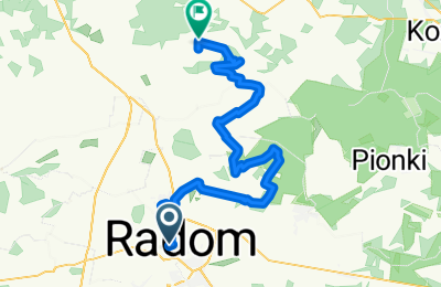
Cycling Route in Radom, Masovian Voivodeship, Poland

11 XI, Puszcza Kozienicka, MEW Goryń, bunkry Sowie Góry

0
Open this route in the Bikemap app

Open this route in the Bikemap app

Open this route in Bikemap Web

Open this route in Bikemap Web

58 km
Distance
263 m
Ascent
271 m
Descent
-:-- h
Duration
-- km/h
Avg. Speed
173 m
Max. Elevation

About This Route

Pomnik Czynu Legionów (radomski Rynek); Dąb Niepodległości - pomnik przyrody, grób Stanisława Wernera (Las Kapturski); Trzy Krzyże (cmentarz Firlej); bród, rz. Mnich (Rajec Poduchowny), kładka, rz. Pacynka, Aleja Dębów, Szlabanowa Droga, Wielka Góra, grań wydmy leśnej, zjazd enduro, Gościniec Królewski, bunkier B14, B13, DDR na DP 3517W (Puszcza Kozienicka), Wola Owadowska-Wolica, Jastrzębia-Poręby Jastrzębskie, dolina rz. Radomki, MEW Goryń, Łowisko Trzy Stawy, Wola Goryńska, Wolska Dąbrowa, B12, B1, B2, B3, B4, B8, B9, B10, B7, B6, B5, B11 (las Sowie Góry), Wierzchowiny, Kruszyna p.o. PKP.

This cycling route is ideal for: MTB

You will cycle on the following surfaces: Unpaved

Customize this cycling route with the Bikemap route planner.

Make it yours!

Did you know? You can use this route as a template in our cycling route planner if you don't wish to start from scratch. Customize it based on your needs to plan your perfect cycling tour.

Open it in the app