

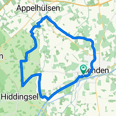
Senden-Dülmen-Rorup-Buldern-Appelhülsen-Senden
A cycling route starting in Senden, North Rhine-Westphalia, Germany.
Overview
About this route
- 3 h 20 min
- Duration
- 54.3 km
- Distance
- 144 m
- Ascent
- 144 m
- Descent
- 16.3 km/h
- Avg. speed
- 93 m
- Avg. speed
Route quality
Waytypes & surfaces along the route
Waytypes
Path
24.5 km
(45 %)
Quiet road
10.2 km
(19 %)
Surfaces
Paved
44.7 km
(82 %)
Unpaved
0.1 km
(<1 %)
Asphalt
41.6 km
(77 %)
Paving stones
2.2 km
(4 %)
Route highlights
Points of interest along the route

Point of interest after 38.6 km
Klosterschänke Karthaus

Point of interest after 42.1 km
Cafe Adelchen
Continue with Bikemap
Use, edit, or download this cycling route
You would like to ride Senden-Dülmen-Rorup-Buldern-Appelhülsen-Senden or customize it for your own trip? Here is what you can do with this Bikemap route:
Free features
- Save this route as favorite or in collections
- Copy & plan your own version of this route
- Sync your route with Garmin or Wahoo
Premium features
Free trial for 3 days, or one-time payment. More about Bikemap Premium.
- Navigate this route on iOS & Android
- Export a GPX / KML file of this route
- Create your custom printout (try it for free)
- Download this route for offline navigation
Discover more Premium features.
Get Bikemap PremiumFrom our community
Other popular routes starting in Senden
 MS-Land_51km_Venner Moor
- Distance
- 51.1 km
- Ascent
- 61 m
- Descent
- 65 m
- Location
- Senden, North Rhine-Westphalia, Germany
 pättkestour westl. senden
- Distance
- 22.5 km
- Ascent
- 60 m
- Descent
- 60 m
- Location
- Senden, North Rhine-Westphalia, Germany
 Samstag, Senden-Davensberg-Nordkirchen-Lüdinghausen-Senden
- Distance
- 63 km
- Ascent
- 156 m
- Descent
- 157 m
- Location
- Senden, North Rhine-Westphalia, Germany
 CE110916
- Distance
- 22.8 km
- Ascent
- 39 m
- Descent
- 37 m
- Location
- Senden, North Rhine-Westphalia, Germany
 Zum Lüdinghausener Schloss
- Distance
- 57.6 km
- Ascent
- 70 m
- Descent
- 70 m
- Location
- Senden, North Rhine-Westphalia, Germany
 Route nach De Moer
- Distance
- 68.6 km
- Ascent
- 385 m
- Descent
- 350 m
- Location
- Senden, North Rhine-Westphalia, Germany
 Venner Moor
- Distance
- 4.9 km
- Ascent
- 13 m
- Descent
- 15 m
- Location
- Senden, North Rhine-Westphalia, Germany
 von Otti zum Longinusturm
- Distance
- 51.9 km
- Ascent
- 189 m
- Descent
- 192 m
- Location
- Senden, North Rhine-Westphalia, Germany
Open it in the app