

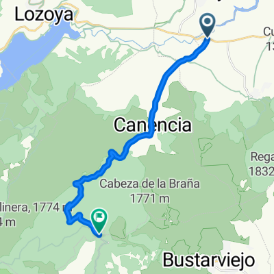
CANENCIA, por Canencia
A cycling route starting in Garganta de los Montes, Madrid, Spain.
Overview
About this route
- -:--
- Duration
- 13.9 km
- Distance
- 530 m
- Ascent
- 53 m
- Descent
- ---
- Avg. speed
- ---
- Avg. speed

Route quality
Waytypes & surfaces along the route
Waytypes
Road
13.9 km
(100 %)
Continue with Bikemap
Use, edit, or download this cycling route
You would like to ride CANENCIA, por Canencia or customize it for your own trip? Here is what you can do with this Bikemap route:
Free features
- Save this route as favorite or in collections
- Copy & plan your own version of this route
- Sync your route with Garmin or Wahoo
Premium features
Free trial for 3 days, or one-time payment. More about Bikemap Premium.
- Navigate this route on iOS & Android
- Export a GPX / KML file of this route
- Create your custom printout (try it for free)
- Download this route for offline navigation
Discover more Premium features.
Get Bikemap PremiumFrom our community
Other popular routes starting in Garganta de los Montes
 Garganta - La Granja - Navafría
- Distance
- 126.5 km
- Ascent
- 1,706 m
- Descent
- 1,710 m
- Location
- Garganta de los Montes, Madrid, Spain
 CANENCIA, por Canencia
- Distance
- 13.9 km
- Ascent
- 530 m
- Descent
- 53 m
- Location
- Garganta de los Montes, Madrid, Spain
 Loyozuela - Puebla de la Sierra
- Distance
- 72.1 km
- Ascent
- 1,074 m
- Descent
- 1,072 m
- Location
- Garganta de los Montes, Madrid, Spain
 tres picos
- Distance
- 95.3 km
- Ascent
- 1,958 m
- Descent
- 2,028 m
- Location
- Garganta de los Montes, Madrid, Spain
 Desafio Ptos. Guadarrama - Tramo 3
- Distance
- 48.4 km
- Ascent
- 729 m
- Descent
- 856 m
- Location
- Garganta de los Montes, Madrid, Spain
 gargantilla de lozoya-navacerrada
- Distance
- 115.2 km
- Ascent
- 1,831 m
- Descent
- 1,806 m
- Location
- Garganta de los Montes, Madrid, Spain
 garganta - cotos - navacerrada - soto - garganta
- Distance
- 111.3 km
- Ascent
- 1,531 m
- Descent
- 1,531 m
- Location
- Garganta de los Montes, Madrid, Spain
 Garganta - La Acebeda
- Distance
- 63.5 km
- Ascent
- 1,209 m
- Descent
- 1,209 m
- Location
- Garganta de los Montes, Madrid, Spain
Open it in the app