Premium Badge Download on the App Store Get it on Google Play Turn-by-turn Navigation Offline Maps Bike Type Optimized Routing Premium Maps Custom Bike Computer Export Routes Route Previews Fall Detection Premium Support

Cycling Route in Cáceres, Extremadura, Spain

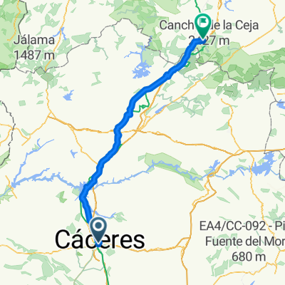
Cáceres- Vía de la Plata-Santuario Alta Gracia

1
Open this route in the Bikemap app

Open this route in the Bikemap app

Open this route in Bikemap Web

Open this route in Bikemap Web

71 km
Distance
319 m
Ascent
319 m
Descent
-:-- h
Duration
-- km/h
Avg. Speed
--- m
Max. Elevation

About This Route

<span style="font-size: small;">Itinerario en BTT por los alrededores de Cáceres. Partiendo de Cáceres se recorren los Llanos de Cáceres y Sierra de Fuentes (Z.E.P.A.), siguiendo la Vía de la Plata hacia el norte, pasando por Casar de Cáceres, hasta el Embalse de Alcántara, para retornar por el Camino de Alta Gracia a la Perala, visitando el Santuario de Alta Gracia y la Ermita de la Virgen del Prado. Después de seguir el trazado del tren desmantelado hasta la Estación Arroyo-Malpartida, se toma el Camino de Arroyo para enlazar con la N-521 cerca del Caserío de los Arenales y entrar en Cáceres por Los Castellanos.</span>

<span style="font-size: small;">Rutas BTT. Extremadura. Alrededores de Cáceres.</span><br />

This cycling route is ideal for: MTB

You will cycle on the following surfaces: Paved Unpaved

Customize this cycling route with the Bikemap route planner.

Make it yours!

Did you know? You can use this route as a template in our cycling route planner if you don't wish to start from scratch. Customize it based on your needs to plan your perfect cycling tour.

Open it in the app