

Bike’n Bier: Das haben wir uns verdient
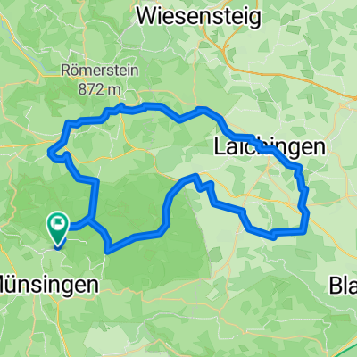
A cycling route starting in Münsingen, Baden-Württemberg, Germany.
Overview
About this route
Der Name ist Programm. Neben schwäbischer Kultur und Landschaft sind einige der vielfältigen Einkehrschwünge ein zu planen. (Tourbeschreibung unter: thod_er@gmx.de)
- -:--
- Duration
- 63.4 km
- Distance
- 1,125 m
- Ascent
- 1,124 m
- Descent
- ---
- Avg. speed
- 780 m
- Avg. speed
Route quality
Waytypes & surfaces along the route
Waytypes
Track
17.8 km
(28 %)
Road
16.1 km
(25 %)
Surfaces
Paved
34.7 km
(55 %)
Unpaved
8.8 km
(14 %)
Asphalt
33.4 km
(53 %)
Gravel
4.8 km
(8 %)
Continue with Bikemap
Use, edit, or download this cycling route
You would like to ride Bike’n Bier: Das haben wir uns verdient or customize it for your own trip? Here is what you can do with this Bikemap route:
Free features
- Save this route as favorite or in collections
- Copy & plan your own version of this route
- Sync your route with Garmin or Wahoo
Premium features
Free trial for 3 days, or one-time payment. More about Bikemap Premium.
- Navigate this route on iOS & Android
- Export a GPX / KML file of this route
- Create your custom printout (try it for free)
- Download this route for offline navigation
Discover more Premium features.
Get Bikemap PremiumFrom our community
Other popular routes starting in Münsingen
 Buchbare Tour 4 | 4. Tag Variante 1
- Distance
- 8 km
- Ascent
- 145 m
- Descent
- 141 m
- Location
- Münsingen, Baden-Württemberg, Germany
 Alb Gold Trophy 2007
- Distance
- 80 km
- Ascent
- 837 m
- Descent
- 837 m
- Location
- Münsingen, Baden-Württemberg, Germany
 50 Samstag 2025
- Distance
- 50 km
- Ascent
- 611 m
- Descent
- 610 m
- Location
- Münsingen, Baden-Württemberg, Germany
 MÜNSINGER E-BIKE TOUR 1: Gestütshof und Rutschenfelsen
- Distance
- 45.2 km
- Ascent
- 657 m
- Descent
- 660 m
- Location
- Münsingen, Baden-Württemberg, Germany
 Über die Albhöhen ins Lautertal
- Distance
- 38.4 km
- Ascent
- 665 m
- Descent
- 680 m
- Location
- Münsingen, Baden-Württemberg, Germany
 e-Bike Tour 3 / Gruorn und Trailfinger Schlucht
- Distance
- 41.8 km
- Ascent
- 693 m
- Descent
- 693 m
- Location
- Münsingen, Baden-Württemberg, Germany
 Trailfinger Säge-Laichingen
- Distance
- 59.4 km
- Ascent
- 857 m
- Descent
- 856 m
- Location
- Münsingen, Baden-Württemberg, Germany
 Buchbare Tour 4 | 3. Tag
- Distance
- 18.1 km
- Ascent
- 334 m
- Descent
- 333 m
- Location
- Münsingen, Baden-Württemberg, Germany
Open it in the app