

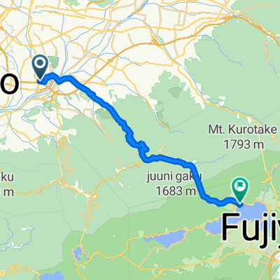
甲府盆地北回りコース
A cycling route starting in Kofu, Yamanashi, Japan.
Overview
About this route
- -:--
- Duration
- 44.1 km
- Distance
- 1,255 m
- Ascent
- 1,254 m
- Descent
- ---
- Avg. speed
- 934 m
- Avg. speed

Continue with Bikemap
Use, edit, or download this cycling route
You would like to ride 甲府盆地北回りコース or customize it for your own trip? Here is what you can do with this Bikemap route:
Free features
- Save this route as favorite or in collections
- Copy & plan your own version of this route
- Sync your route with Garmin or Wahoo
Premium features
Free trial for 3 days, or one-time payment. More about Bikemap Premium.
- Navigate this route on iOS & Android
- Export a GPX / KML file of this route
- Create your custom printout (try it for free)
- Download this route for offline navigation
Discover more Premium features.
Get Bikemap PremiumFrom our community
Other popular routes starting in Kofu
 宝, 甲府市 to 宝, 甲府市
- Distance
- 115.6 km
- Ascent
- 1,211 m
- Descent
- 1,212 m
- Location
- Kofu, Yamanashi, Japan
 甲府盆地北回りコース
- Distance
- 44.1 km
- Ascent
- 1,255 m
- Descent
- 1,254 m
- Location
- Kofu, Yamanashi, Japan
 Kofu to Oishi Park, Fujikawaguchiko
- Distance
- 26.6 km
- Ascent
- 1,620 m
- Descent
- 1,040 m
- Location
- Kofu, Yamanashi, Japan
 Kofu to home (?)
- Distance
- 154.4 km
- Ascent
- 3,286 m
- Descent
- 3,564 m
- Location
- Kofu, Yamanashi, Japan
 甲府盆地大回りコース
- Distance
- 48.2 km
- Ascent
- 158 m
- Descent
- 158 m
- Location
- Kofu, Yamanashi, Japan
 宝2丁目15-14, 甲府市 to 宝1丁目34-12, 甲府市
- Distance
- 128.5 km
- Ascent
- 1,256 m
- Descent
- 1,253 m
- Location
- Kofu, Yamanashi, Japan
 Kufo to Yamanakako
- Distance
- 59 km
- Ascent
- 1,263 m
- Descent
- 547 m
- Location
- Kofu, Yamanashi, Japan
 ETAPA 19. Kofu - Lake Motosu/Lake Shoji
- Distance
- 57.5 km
- Ascent
- 1,073 m
- Descent
- 444 m
- Location
- Kofu, Yamanashi, Japan
Open it in the app