

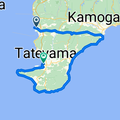
房総素掘りトンネル巡り
A cycling route starting in Tateyama, Chiba, Japan.
Overview
About this route
TABIRIN Download
- -:--
- Duration
- 45.5 km
- Distance
- 731 m
- Ascent
- 731 m
- Descent
- ---
- Avg. speed
- 171 m
- Avg. speed

Continue with Bikemap
Use, edit, or download this cycling route
You would like to ride 房総素掘りトンネル巡り or customize it for your own trip? Here is what you can do with this Bikemap route:
Free features
- Save this route as favorite or in collections
- Copy & plan your own version of this route
- Sync your route with Garmin or Wahoo
Premium features
Free trial for 3 days, or one-time payment. More about Bikemap Premium.
- Navigate this route on iOS & Android
- Export a GPX / KML file of this route
- Create your custom printout (try it for free)
- Download this route for offline navigation
Discover more Premium features.
Get Bikemap PremiumFrom our community
Other popular routes starting in Tateyama
 BAC-Chikura-Wadaura
- Distance
- 11.5 km
- Ascent
- 66 m
- Descent
- 79 m
- Location
- Tateyama, Chiba, Japan
 南房総“菜の花サイクリング"
- Distance
- 57.8 km
- Ascent
- 347 m
- Descent
- 346 m
- Location
- Tateyama, Chiba, Japan
 20210919 南房総
- Distance
- 61.8 km
- Ascent
- 264 m
- Descent
- 261 m
- Location
- Tateyama, Chiba, Japan
 Awakatsuyama-Awakamogawa-Chikura-Tateyama
- Distance
- 95.2 km
- Ascent
- 299 m
- Descent
- 298 m
- Location
- Tateyama, Chiba, Japan
 Uchibo from Tomiura to Chibo
- Distance
- 49.3 km
- Ascent
- 120 m
- Descent
- 121 m
- Location
- Tateyama, Chiba, Japan
 Hota-Mineoka-Chikura-Tateyama
- Distance
- 101.8 km
- Ascent
- 586 m
- Descent
- 592 m
- Location
- Tateyama, Chiba, Japan
 CCA里山・里海サイクリング 2020
- Distance
- 65 km
- Ascent
- 801 m
- Descent
- 806 m
- Location
- Tateyama, Chiba, Japan
 Minami Boso Loop
- Distance
- 58.9 km
- Ascent
- 176 m
- Descent
- 176 m
- Location
- Tateyama, Chiba, Japan
Open it in the app