
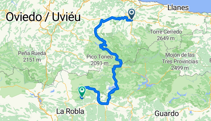
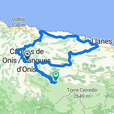
Falkenfels Bühlertal 2. Etappe: Cangas-Vegacervera
A cycling route starting in Cangas de Onis, Principality of Asturias, Spain.
Overview
About this route
Wir durchqueren den westlichen Teil der Cordillera Cantábrica von Nord nach Südwesten. Über mehrere, auch längere Pässe fahren wir durch die von Wäldern, Almen und schroffen Gipfeln geprägte Nordhälfte in die trockene Hochebene von León mit einer landschaftlichen Überraschung am Schluss. info@naturatour.com
- -:--
- Duration
- 165.8 km
- Distance
- 4,626 m
- Ascent
- 3,566 m
- Descent
- ---
- Avg. speed
- 1,635 m
- Avg. speed
Route quality
Waytypes & surfaces along the route
Waytypes
Busy road
78.3 km
(47 %)
Road
50.3 km
(30 %)
Surfaces
Paved
109.3 km
(66 %)
Unpaved
0.8 km
(<1 %)
Asphalt
109.3 km
(66 %)
Gravel
0.8 km
(<1 %)
Undefined
55.7 km
(34 %)
Continue with Bikemap
Use, edit, or download this cycling route
You would like to ride Falkenfels Bühlertal 2. Etappe: Cangas-Vegacervera or customize it for your own trip? Here is what you can do with this Bikemap route:
Free features
- Save this route as favorite or in collections
- Copy & plan your own version of this route
- Sync your route with Garmin or Wahoo
Premium features
Free trial for 3 days, or one-time payment. More about Bikemap Premium.
- Navigate this route on iOS & Android
- Export a GPX / KML file of this route
- Create your custom printout (try it for free)
- Download this route for offline navigation
Discover more Premium features.
Get Bikemap PremiumFrom our community
Other popular routes starting in Cangas de Onis
 Clasica Lagos 2011
- Distance
- 110.1 km
- Ascent
- 1,823 m
- Descent
- 808 m
- Location
- Cangas de Onis, Principality of Asturias, Spain
 Days 3 & 4 Cangas De Onis - Leon 185 ON Vuelta and here 185
- Distance
- 184.1 km
- Ascent
- 3,502 m
- Descent
- 2,723 m
- Location
- Cangas de Onis, Principality of Asturias, Spain
 Lagos de covadonga
- Distance
- 36.4 km
- Ascent
- 1,473 m
- Descent
- 1,110 m
- Location
- Cangas de Onis, Principality of Asturias, Spain
 La Vuelta Stage 7
- Distance
- 138.4 km
- Ascent
- 2,951 m
- Descent
- 2,708 m
- Location
- Cangas de Onis, Principality of Asturias, Spain
 CLASICA LAGOS
- Distance
- 136.5 km
- Ascent
- 1,772 m
- Descent
- 1,778 m
- Location
- Cangas de Onis, Principality of Asturias, Spain
 Cangas-Lago Enol
- Distance
- 20.5 km
- Ascent
- 1,095 m
- Descent
- 55 m
- Location
- Cangas de Onis, Principality of Asturias, Spain
 Cares d1 v6b
- Distance
- 50.1 km
- Ascent
- 956 m
- Descent
- 958 m
- Location
- Cangas de Onis, Principality of Asturias, Spain
 Lagos de Covadonga
- Distance
- 19.3 km
- Ascent
- 1,150 m
- Descent
- 108 m
- Location
- Cangas de Onis, Principality of Asturias, Spain
Open it in the app