
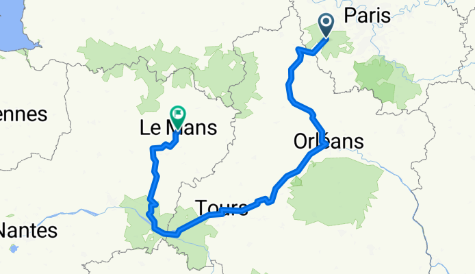
La Loire à vélo - Orléans - Le Mans
A cycling route starting in Auffargis, Île-de-France Region, France.
Overview
About this route
- 31 h 26 min
- Duration
- 505 km
- Distance
- 2,220 m
- Ascent
- 2,344 m
- Descent
- 16.1 km/h
- Avg. speed
- 183 m
- Avg. speed
Route quality
Waytypes & surfaces along the route
Waytypes
Quiet road
180.7 km
(36 %)
Road
161.3 km
(32 %)
Surfaces
Paved
210.2 km
(42 %)
Unpaved
53.3 km
(11 %)
Asphalt
198.3 km
(39 %)
Gravel
39.2 km
(8 %)
Continue with Bikemap
Use, edit, or download this cycling route
You would like to ride La Loire à vélo - Orléans - Le Mans or customize it for your own trip? Here is what you can do with this Bikemap route:
Free features
- Save this route as favorite or in collections
- Copy & plan your own version of this route
- Sync your route with Garmin or Wahoo
Premium features
Free trial for 3 days, or one-time payment. More about Bikemap Premium.
- Navigate this route on iOS & Android
- Export a GPX / KML file of this route
- Create your custom printout (try it for free)
- Download this route for offline navigation
Discover more Premium features.
Get Bikemap PremiumFrom our community
Other popular routes starting in Auffargis
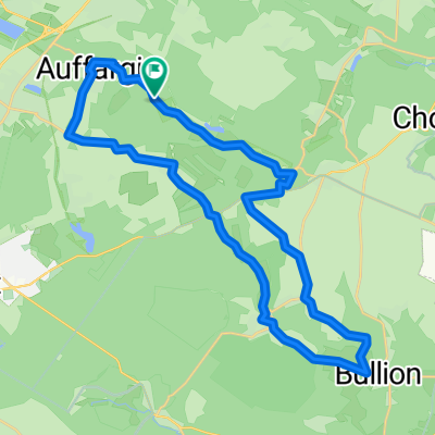 Auffargis Bullion
- Distance
- 31.1 km
- Ascent
- 195 m
- Descent
- 195 m
- Location
- Auffargis, Île-de-France Region, France
 Yvelines
- Distance
- 11.6 km
- Ascent
- 78 m
- Descent
- 79 m
- Location
- Auffargis, Île-de-France Region, France
 V 24
V 24- Distance
- 24.3 km
- Ascent
- 92 m
- Descent
- 91 m
- Location
- Auffargis, Île-de-France Region, France
 VTT auffargis 5
- Distance
- 34 km
- Ascent
- 447 m
- Descent
- 441 m
- Location
- Auffargis, Île-de-France Region, France
 V 45
V 45- Distance
- 45.1 km
- Ascent
- 335 m
- Descent
- 332 m
- Location
- Auffargis, Île-de-France Region, France
 La Loire à vélo - Orléans - Le Mans
- Distance
- 505 km
- Ascent
- 2,220 m
- Descent
- 2,344 m
- Location
- Auffargis, Île-de-France Region, France
 V 42
V 42- Distance
- 42 km
- Ascent
- 215 m
- Descent
- 215 m
- Location
- Auffargis, Île-de-France Region, France
 MAINTENON-AUFFARGIS
- Distance
- 80.9 km
- Ascent
- 178 m
- Descent
- 178 m
- Location
- Auffargis, Île-de-France Region, France
Open it in the app