Premium Badge Download on the App Store Get it on Google Play Turn-by-turn Navigation Offline Maps Bike Type Optimized Routing Premium Maps Custom Bike Computer Export Routes Route Previews Fall Detection Premium Support

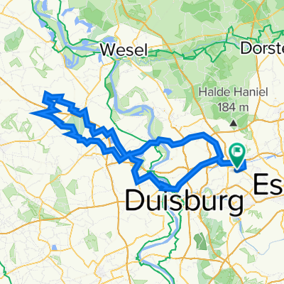
Cycling Route in Oberhausen, North Rhine-Westphalia, Germany

Grüner Pfad - HOAG-Trasse - Hühnerheide - Hiesfelder Wald

2
Open this route in the Bikemap app

Open this route in the Bikemap app

Open this route in Bikemap Web

Open this route in Bikemap Web

62 km
Distance
242 m
Ascent
243 m
Descent
3:58 h
Duration
-- km/h
Avg. Speed
80 m
Max. Elevation

About This Route

Start- und Zielpunkt: In Hostel Veritas an der Essener Straße in Oberhausen. Zunächst am Rhein-Herne-Kanal entlang zum Duisburger Hafen, dann über den Grünen Pfad und der HOAG-Trasse in den Oberhausener Norden. Durch die Hühnerheide zum Hiesfelder Wald und zurück zum Ausgangspunkt. Abwechslunsreiche Strecke: Leinpfad, ehemalige Bahntrassen und Wald, von allem etwas.

This cycling route is ideal for: MTB City bike

You will cycle on the following surfaces: Paved Unpaved Gravel

Route Photos

Customize this cycling route with the Bikemap route planner.

Make it yours!

Did you know? You can use this route as a template in our cycling route planner if you don't wish to start from scratch. Customize it based on your needs to plan your perfect cycling tour.

Open it in the app