

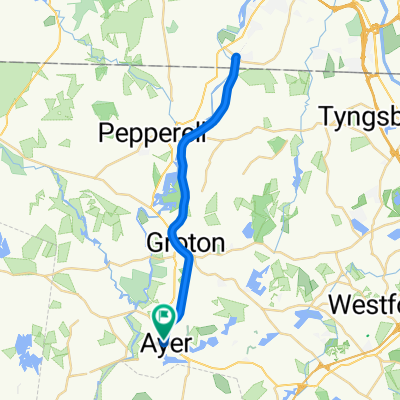
21 Park St, Ayer to Nashua River Rail Trail, Nashua
A cycling route starting in Ayer, Massachusetts, United States of America.
Overview
About this route
- 58 min
- Duration
- 18.7 km
- Distance
- 239 m
- Ascent
- 178 m
- Descent
- 19.3 km/h
- Avg. speed
- 100 m
- Avg. speed

Route quality
Waytypes & surfaces along the route
Waytypes
Cycleway
17.7 km
(95 %)
Path
0.6 km
(3 %)
Surfaces
Paved
18.6 km
(99 %)
Paved (undefined)
16.2 km
(87 %)
Asphalt
2.4 km
(13 %)
Undefined
0.1 km
(<1 %)
Continue with Bikemap
Use, edit, or download this cycling route
You would like to ride 21 Park St, Ayer to Nashua River Rail Trail, Nashua or customize it for your own trip? Here is what you can do with this Bikemap route:
Free features
- Save this route as favorite or in collections
- Copy & plan your own version of this route
- Sync your route with Garmin or Wahoo
Premium features
Free trial for 3 days, or one-time payment. More about Bikemap Premium.
- Navigate this route on iOS & Android
- Export a GPX / KML file of this route
- Create your custom printout (try it for free)
- Download this route for offline navigation
Discover more Premium features.
Get Bikemap PremiumFrom our community
Other popular routes starting in Ayer
 Ayer Rail Trail
- Distance
- 33 km
- Ascent
- 105 m
- Descent
- 105 m
- Location
- Ayer, Massachusetts, United States of America
 19mi Boxboro
- Distance
- 32.6 km
- Ascent
- 326 m
- Descent
- 326 m
- Location
- Ayer, Massachusetts, United States of America
 Nashua River Trail
- Distance
- 39.2 km
- Ascent
- 221 m
- Descent
- 219 m
- Location
- Ayer, Massachusetts, United States of America
 Nashua River Rail Trail Out & Back
- Distance
- 39.1 km
- Ascent
- 211 m
- Descent
- 210 m
- Location
- Ayer, Massachusetts, United States of America
 27mi around Boxboro
- Distance
- 43.8 km
- Ascent
- 277 m
- Descent
- 278 m
- Location
- Ayer, Massachusetts, United States of America
 Devens 10mi
- Distance
- 15.9 km
- Ascent
- 96 m
- Descent
- 97 m
- Location
- Ayer, Massachusetts, United States of America
 test
test- Distance
- 6.2 km
- Ascent
- 41 m
- Descent
- 28 m
- Location
- Ayer, Massachusetts, United States of America
 Alzheimer Ride
- Distance
- 45.6 km
- Ascent
- 180 m
- Descent
- 180 m
- Location
- Ayer, Massachusetts, United States of America
Open it in the app