

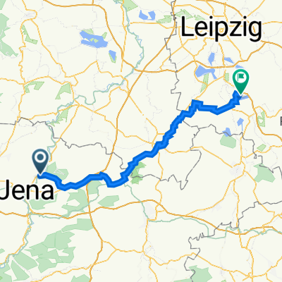
Jena-Hohenwarte-Talsperre
A cycling route starting in Neuengönna, Free State of Thuringia, Germany.
Overview
About this route
- -:--
- Duration
- 169.1 km
- Distance
- 2,350 m
- Ascent
- 2,274 m
- Descent
- ---
- Avg. speed
- 535 m
- Avg. speed
Route quality
Waytypes & surfaces along the route
Waytypes
Busy road
87.4 km
(52 %)
Road
27.7 km
(16 %)
Surfaces
Paved
113.5 km
(67 %)
Unpaved
9.4 km
(6 %)
Asphalt
107.7 km
(64 %)
Ground
4.3 km
(3 %)
Continue with Bikemap
Use, edit, or download this cycling route
You would like to ride Jena-Hohenwarte-Talsperre or customize it for your own trip? Here is what you can do with this Bikemap route:
Free features
- Save this route as favorite or in collections
- Copy & plan your own version of this route
- Sync your route with Garmin or Wahoo
Premium features
Free trial for 3 days, or one-time payment. More about Bikemap Premium.
- Navigate this route on iOS & Android
- Export a GPX / KML file of this route
- Create your custom printout (try it for free)
- Download this route for offline navigation
Discover more Premium features.
Get Bikemap PremiumFrom our community
Other popular routes starting in Neuengönna
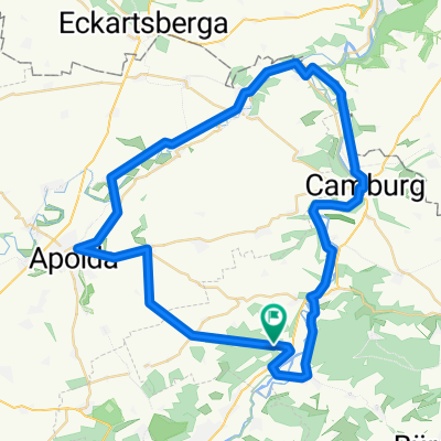
 Jena-Camburg
- Distance
- 17.9 km
- Ascent
- 127 m
- Descent
- 143 m
- Location
- Neuengönna, Free State of Thuringia, Germany
 6. Jena Rabeninsel_ Hainer See
- Distance
- 91.5 km
- Ascent
- 479 m
- Descent
- 484 m
- Location
- Neuengönna, Free State of Thuringia, Germany
 25.10.2015 Über Luftschiff,,Kirchenradweg Brauverein Jenaprisnitz .gpx
- Distance
- 35.8 km
- Ascent
- 346 m
- Descent
- 354 m
- Location
- Neuengönna, Free State of Thuringia, Germany
 Saale-Ilm-Saale-Tour
- Distance
- 51.1 km
- Ascent
- 439 m
- Descent
- 439 m
- Location
- Neuengönna, Free State of Thuringia, Germany
 20150719_124631.gpx
- Distance
- 52.2 km
- Ascent
- 373 m
- Descent
- 368 m
- Location
- Neuengönna, Free State of Thuringia, Germany
 23_3 Jena - Mühlenradweg - Jena Bhf
- Distance
- 59.5 km
- Ascent
- 617 m
- Descent
- 597 m
- Location
- Neuengönna, Free State of Thuringia, Germany
 Auf die Hohe Lehde bei Jena
- Distance
- 41.3 km
- Ascent
- 421 m
- Descent
- 410 m
- Location
- Neuengönna, Free State of Thuringia, Germany
 Weingut Zahn und zurück
- Distance
- 54.6 km
- Ascent
- 453 m
- Descent
- 453 m
- Location
- Neuengönna, Free State of Thuringia, Germany
Open it in the app