

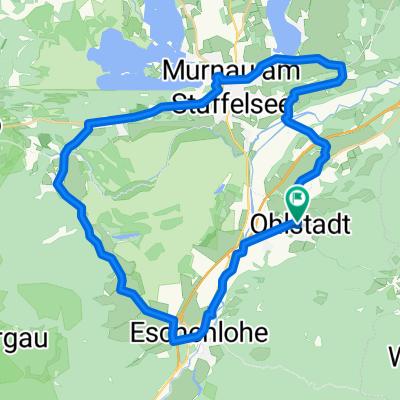
Murnauer Moos Runde - Ähndl Grafenaschau
A cycling route starting in Ohlstadt, Bavaria, Germany.
Overview
About this route
- -:--
- Duration
- 28.2 km
- Distance
- 141 m
- Ascent
- 141 m
- Descent
- ---
- Avg. speed
- ---
- Avg. speed
Route quality
Waytypes & surfaces along the route
Waytypes
Track
14.8 km
(52 %)
Quiet road
7.1 km
(25 %)
Surfaces
Paved
16.7 km
(59 %)
Unpaved
10.5 km
(37 %)
Asphalt
16.5 km
(58 %)
Gravel
5.6 km
(20 %)
Continue with Bikemap
Use, edit, or download this cycling route
You would like to ride Murnauer Moos Runde - Ähndl Grafenaschau or customize it for your own trip? Here is what you can do with this Bikemap route:
Free features
- Save this route as favorite or in collections
- Copy & plan your own version of this route
- Sync your route with Garmin or Wahoo
Premium features
Free trial for 3 days, or one-time payment. More about Bikemap Premium.
- Navigate this route on iOS & Android
- Export a GPX / KML file of this route
- Create your custom printout (try it for free)
- Download this route for offline navigation
Discover more Premium features.
Get Bikemap PremiumFrom our community
Other popular routes starting in Ohlstadt
 Murnauer Moosrunde
- Distance
- 30.7 km
- Ascent
- 132 m
- Descent
- 132 m
- Location
- Ohlstadt, Bavaria, Germany
 MTB Walchensee/Ohlstadt
- Distance
- 50.2 km
- Ascent
- 893 m
- Descent
- 896 m
- Location
- Ohlstadt, Bavaria, Germany
 Ohlstad via Eschelaine
- Distance
- 17.9 km
- Ascent
- 1,612 m
- Descent
- 882 m
- Location
- Ohlstadt, Bavaria, Germany
 Pässlich 01 - Alternativroute
- Distance
- 122.4 km
- Ascent
- 1,651 m
- Descent
- 1,498 m
- Location
- Ohlstadt, Bavaria, Germany
 Ohlstadt-Hohenkasten-Ohlstadt
- Distance
- 59.5 km
- Ascent
- 412 m
- Descent
- 409 m
- Location
- Ohlstadt, Bavaria, Germany
 Schwaiganger - Garmisch - Eibsee
- Distance
- 37.4 km
- Ascent
- 381 m
- Descent
- 264 m
- Location
- Ohlstadt, Bavaria, Germany
 MOP-T_V1
- Distance
- 37.1 km
- Ascent
- 338 m
- Descent
- 338 m
- Location
- Ohlstadt, Bavaria, Germany
 Von Ohlstadt übers Katzental nach Partenkirchen
- Distance
- 42.7 km
- Ascent
- 358 m
- Descent
- 358 m
- Location
- Ohlstadt, Bavaria, Germany
Open it in the app