

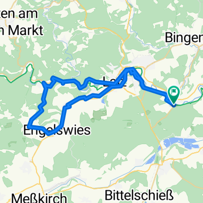
2024 - D - Tag 2 - Sigmaringendorf - Munderkingen
A cycling route starting in Sigmaringendorf, Baden-Wurttemberg, Germany.
Overview
About this route
- 3 h 36 min
- Duration
- 57.3 km
- Distance
- 353 m
- Ascent
- 413 m
- Descent
- 15.9 km/h
- Avg. speed
- 601 m
- Max. altitude

Route quality
Waytypes & surfaces along the route
Waytypes
Track
22.5 km
(39 %)
Quiet road
21.6 km
(38 %)
Surfaces
Paved
42.3 km
(74 %)
Unpaved
7.3 km
(13 %)
Asphalt
41.9 km
(73 %)
Gravel
4.3 km
(8 %)
Continue with Bikemap
Use, edit, or download this cycling route
You would like to ride 2024 - D - Tag 2 - Sigmaringendorf - Munderkingen or customize it for your own trip? Here is what you can do with this Bikemap route:
Free features
- Save this route as favorite or in collections
- Copy & plan your own version of this route
- Sync your route with Garmin or Wahoo
Premium features
Free trial for 3 days, or one-time payment. More about Bikemap Premium.
- Navigate this route on iOS & Android
- Export a GPX / KML file of this route
- Create your custom printout (try it for free)
- Download this route for offline navigation
Discover more Premium features.
Get Bikemap PremiumFrom our community
Other popular routes starting in Sigmaringendorf
 Tour um Sigmaringen ab Sigmaringendorf
- Distance
- 38.1 km
- Ascent
- 295 m
- Descent
- 295 m
- Location
- Sigmaringendorf, Baden-Wurttemberg, Germany
 Häldele 1, Sigmaringendorf nach Grötzelstraße 39, Friedrichshafen
- Distance
- 56.4 km
- Ascent
- 798 m
- Descent
- 933 m
- Location
- Sigmaringendorf, Baden-Wurttemberg, Germany
 Bahnhofstraße 1, Sigmaringendorf nach Schlesierstraße 1, Sigmaringendorf
- Distance
- 73.5 km
- Ascent
- 1,115 m
- Descent
- 1,105 m
- Location
- Sigmaringendorf, Baden-Wurttemberg, Germany
 Grand Canyon an der Donau
- Distance
- 94.1 km
- Ascent
- 574 m
- Descent
- 578 m
- Location
- Sigmaringendorf, Baden-Wurttemberg, Germany
 eurovelo
- Distance
- 1,093.4 km
- Ascent
- 999 m
- Descent
- 1,481 m
- Location
- Sigmaringendorf, Baden-Wurttemberg, Germany
 2019-08-04 Tag 2
- Distance
- 66.7 km
- Ascent
- 156 m
- Descent
- 212 m
- Location
- Sigmaringendorf, Baden-Wurttemberg, Germany
 2019_08_04 MCS Lauchert - Lauter - Donau
- Distance
- 164.1 km
- Ascent
- 411 m
- Descent
- 408 m
- Location
- Sigmaringendorf, Baden-Wurttemberg, Germany
 2016/05/27 - Donauradweg 2. Tag
- Distance
- 119.4 km
- Ascent
- 274 m
- Descent
- 357 m
- Location
- Sigmaringendorf, Baden-Wurttemberg, Germany
Open it in the app