

Ramstein-Miesenbach Rundweg (Bunte Schilder)
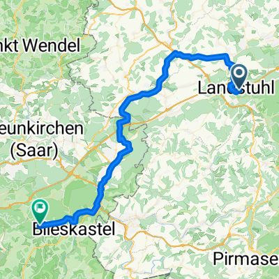
A cycling route starting in Landstuhl, Rhineland-Palatinate, Germany.
Overview
About this route
Ein Rundweg um die gesamte Gemeinde Ramstein-Miesenbach. Man muss den Schildern folgen, die komplett aus allen Ortsteilen bestehen.
- -:--
- Duration
- 39 km
- Distance
- 581 m
- Ascent
- 569 m
- Descent
- ---
- Avg. speed
- 418 m
- Avg. speed
Route quality
Waytypes & surfaces along the route
Waytypes
Track
23.5 km
(60 %)
Quiet road
6.1 km
(16 %)
Surfaces
Paved
27.6 km
(71 %)
Unpaved
11.2 km
(29 %)
Asphalt
16.3 km
(42 %)
Paved (undefined)
10.8 km
(28 %)
Continue with Bikemap
Use, edit, or download this cycling route
You would like to ride Ramstein-Miesenbach Rundweg (Bunte Schilder) or customize it for your own trip? Here is what you can do with this Bikemap route:
Free features
- Save this route as favorite or in collections
- Copy & plan your own version of this route
- Sync your route with Garmin or Wahoo
Premium features
Free trial for 3 days, or one-time payment. More about Bikemap Premium.
- Navigate this route on iOS & Android
- Export a GPX / KML file of this route
- Create your custom printout (try it for free)
- Download this route for offline navigation
Discover more Premium features.
Get Bikemap PremiumFrom our community
Other popular routes starting in Landstuhl
 Landstuhl to Weselberg
- Distance
- 27.1 km
- Ascent
- 278 m
- Descent
- 278 m
- Location
- Landstuhl, Rhineland-Palatinate, Germany
 Air-Base Rundtour
- Distance
- 39.9 km
- Ascent
- 157 m
- Descent
- 154 m
- Location
- Landstuhl, Rhineland-Palatinate, Germany
 Radelspaß 2025 ?probably?
- Distance
- 17.9 km
- Ascent
- 374 m
- Descent
- 360 m
- Location
- Landstuhl, Rhineland-Palatinate, Germany
 Olsbrücken Sportplatz und zurück
- Distance
- 49.6 km
- Ascent
- 190 m
- Descent
- 190 m
- Location
- Landstuhl, Rhineland-Palatinate, Germany
 Brief bike tour through Landstuhl
- Distance
- 0.9 km
- Ascent
- 25 m
- Descent
- 9 m
- Location
- Landstuhl, Rhineland-Palatinate, Germany
 130825 DIaRad 2013 Tag 2
- Distance
- 57.7 km
- Ascent
- 171 m
- Descent
- 185 m
- Location
- Landstuhl, Rhineland-Palatinate, Germany
 Burg-Nanstein-Weg
- Distance
- 12.8 km
- Ascent
- 339 m
- Descent
- 336 m
- Location
- Landstuhl, Rhineland-Palatinate, Germany
 2009.2 Beta Lustiger Potzberg
- Distance
- 45.9 km
- Ascent
- 723 m
- Descent
- 747 m
- Location
- Landstuhl, Rhineland-Palatinate, Germany
Open it in the app