

Port Townsend to Olympia
A cycling route starting in Port Townsend, Washington, United States of America.
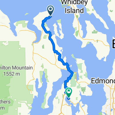
Overview
About this route
Start anywhere you want in Port Townsend, as route 20 is almost the only way to leave town. At the first light continue straight on to Rt. 19. This will bring you to Chimacum. At the blinking red light 4-way stop go right onto Center Rd., which will take you all the way to Quilcene. In Quilcene you will meet 101, which will take you all the way to Olympia. The reason for taking Center Rd is that Rt 20 south of Port Townsend is hilly, curvy, without any shoulder, and dangerous. Center Rd. has a very wide shoulder, as well as many farms and Mt Views.
There is a big hill just before Quilcene, and then a pass between Quilcene and Bremerton. This is the most difficult stretch of the ride. Rt 101 is moderately hilly, and often only a small shoulder. I recommend finding a day outside the main tourist season, when 101 is not heavily travelled. The views of the sound are stunning. Enjoy!
- -:--
- Duration
- 156.7 km
- Distance
- 753 m
- Ascent
- 807 m
- Descent
- ---
- Avg. speed
- ---
- Avg. speed

Continue with Bikemap
Use, edit, or download this cycling route
You would like to ride Port Townsend to Olympia or customize it for your own trip? Here is what you can do with this Bikemap route:
Free features
- Save this route as favorite or in collections
- Copy & plan your own version of this route
- Sync your route with Garmin or Wahoo
Premium features
Free trial for 3 days, or one-time payment. More about Bikemap Premium.
- Navigate this route on iOS & Android
- Export a GPX / KML file of this route
- Create your custom printout (try it for free)
- Download this route for offline navigation
Discover more Premium features.
Get Bikemap PremiumFrom our community
Other popular routes starting in Port Townsend
 152 Hidden Trail Rd, Port Townsend to 2427 Washington St, Port Townsend
- Distance
- 6.6 km
- Ascent
- 48 m
- Descent
- 126 m
- Location
- Port Townsend, Washington, United States of America
 Day 1
Day 1- Distance
- 122.1 km
- Ascent
- 669 m
- Descent
- 606 m
- Location
- Port Townsend, Washington, United States of America
 1300–1398 Clay St, Port Townsend to 18680 State Highway 305 NE, Poulsbo
- Distance
- 63.9 km
- Ascent
- 997 m
- Descent
- 1,005 m
- Location
- Port Townsend, Washington, United States of America
 Olympic Discovery Trail
- Distance
- 84 km
- Ascent
- 517 m
- Descent
- 494 m
- Location
- Port Townsend, Washington, United States of America
 test
test- Distance
- 11.5 km
- Ascent
- 168 m
- Descent
- 125 m
- Location
- Port Townsend, Washington, United States of America
 tyler walk
- Distance
- 3.8 km
- Ascent
- 50 m
- Descent
- 49 m
- Location
- Port Townsend, Washington, United States of America
 628 Water St, Port Townsend nach 9072 Beaver Valley Rd, Chimacum
- Distance
- 23.1 km
- Ascent
- 384 m
- Descent
- 355 m
- Location
- Port Townsend, Washington, United States of America
 Larry Scott
- Distance
- 30.7 km
- Ascent
- 345 m
- Descent
- 347 m
- Location
- Port Townsend, Washington, United States of America
Open it in the app