

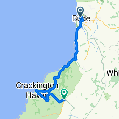
Sandymouth - Bude - Sandymouth
A cycling route starting in Flexbury, England, United Kingdom.
Overview
About this route
- -:--
- Duration
- 10.6 km
- Distance
- 64 m
- Ascent
- 153 m
- Descent
- ---
- Avg. speed
- ---
- Avg. speed

Continue with Bikemap
Use, edit, or download this cycling route
You would like to ride Sandymouth - Bude - Sandymouth or customize it for your own trip? Here is what you can do with this Bikemap route:
Free features
- Save this route as favorite or in collections
- Copy & plan your own version of this route
- Sync your route with Garmin or Wahoo
Premium features
Free trial for 3 days, or one-time payment. More about Bikemap Premium.
- Navigate this route on iOS & Android
- Export a GPX / KML file of this route
- Create your custom printout (try it for free)
- Download this route for offline navigation
Discover more Premium features.
Get Bikemap PremiumFrom our community
Other popular routes starting in Flexbury
 LEJOG_D2
- Distance
- 165.4 km
- Ascent
- 947 m
- Descent
- 1,104 m
- Location
- Flexbury, England, United Kingdom
 south inland loop
- Distance
- 10.3 km
- Ascent
- 512 m
- Descent
- 516 m
- Location
- Flexbury, England, United Kingdom
 West St, Kilkhampton, Bude to Browhill, Ivyleaf Hill, Bude
- Distance
- 3.3 km
- Ascent
- 38 m
- Descent
- 85 m
- Location
- Flexbury, England, United Kingdom
 Wooda Farm Park to Crackington Manor
- Distance
- 22.1 km
- Ascent
- 451 m
- Descent
- 481 m
- Location
- Flexbury, England, United Kingdom
 Crooklets Road nach Marine Drive
- Distance
- 4.7 km
- Ascent
- 94 m
- Descent
- 81 m
- Location
- Flexbury, England, United Kingdom
 10 mile loop
- Distance
- 15.2 km
- Ascent
- 302 m
- Descent
- 302 m
- Location
- Flexbury, England, United Kingdom
 Lejog 2016 - Day 2 - Bude - Bridgwater
- Distance
- 148.9 km
- Ascent
- 1,161 m
- Descent
- 1,163 m
- Location
- Flexbury, England, United Kingdom
 Tintagel 23 km
- Distance
- 22.3 km
- Ascent
- 523 m
- Descent
- 362 m
- Location
- Flexbury, England, United Kingdom
Open it in the app