
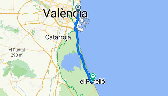
Carrer de Josep Benlliure, 300D, València to Carrer del Presbítero Manuel Aguilar, 10, Sueca
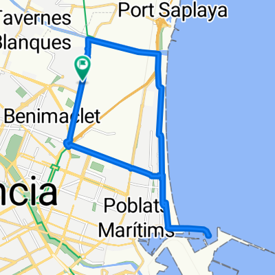
A cycling route starting in Alboraya, Valencia, Spain.
Overview
About this route
- 1 h 39 min
- Duration
- 27.6 km
- Distance
- 70 m
- Ascent
- 65 m
- Descent
- 16.6 km/h
- Avg. speed
- 10 m
- Avg. speed
Route quality
Waytypes & surfaces along the route
Waytypes
Cycleway
11.7 km
(43 %)
Quiet road
5.4 km
(20 %)
Surfaces
Paved
12.4 km
(45 %)
Unpaved
1.8 km
(6 %)
Asphalt
6.6 km
(24 %)
Concrete
2.7 km
(10 %)
Continue with Bikemap
Use, edit, or download this cycling route
You would like to ride Carrer de Josep Benlliure, 300D, València to Carrer del Presbítero Manuel Aguilar, 10, Sueca or customize it for your own trip? Here is what you can do with this Bikemap route:
Free features
- Save this route as favorite or in collections
- Copy & plan your own version of this route
- Sync your route with Garmin or Wahoo
Premium features
Free trial for 3 days, or one-time payment. More about Bikemap Premium.
- Navigate this route on iOS & Android
- Export a GPX / KML file of this route
- Create your custom printout (try it for free)
- Download this route for offline navigation
Discover more Premium features.
Get Bikemap PremiumFrom our community
Other popular routes starting in Alboraya
 alboraya,puerto,malvarrosa,alboraya
- Distance
- 15.4 km
- Ascent
- 34 m
- Descent
- 34 m
- Location
- Alboraya, Valencia, Spain
 VUELTA 2o1o - Valencia/Weinheim
- Distance
- 1,789.9 km
- Ascent
- 878 m
- Descent
- 789 m
- Location
- Alboraya, Valencia, Spain
 20100616-Por la costa
- Distance
- 43.7 km
- Ascent
- 156 m
- Descent
- 43 m
- Location
- Alboraya, Valencia, Spain
 Valencia-Sot de Chera
- Distance
- 199.1 km
- Ascent
- 1,283 m
- Descent
- 1,284 m
- Location
- Alboraya, Valencia, Spain
 Valencia-Sot de Chera
- Distance
- 216.8 km
- Ascent
- 1,702 m
- Descent
- 1,707 m
- Location
- Alboraya, Valencia, Spain
 Valencia - Xativa
- Distance
- 78.5 km
- Ascent
- 146 m
- Descent
- 38 m
- Location
- Alboraya, Valencia, Spain
 20100514-Via Augusta y Raco de Gausa
- Distance
- 36.9 km
- Ascent
- 344 m
- Descent
- 227 m
- Location
- Alboraya, Valencia, Spain
 Valencia - Mola de Segart - Chocainet -Valencia
- Distance
- 56.4 km
- Ascent
- 640 m
- Descent
- 639 m
- Location
- Alboraya, Valencia, Spain
Open it in the app