
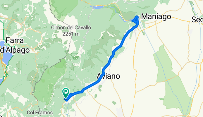
Via San Michele 49, Polcenigo a Via Ruals 7, Polcenigo
A cycling route starting in Polcenigo, Friuli Venezia Giulia, Italy.
Overview
About this route
- 3 h 1 min
- Duration
- 51.9 km
- Distance
- 1,061 m
- Ascent
- 1,077 m
- Descent
- 17.2 km/h
- Avg. speed
- 396 m
- Avg. speed

Route quality
Waytypes & surfaces along the route
Waytypes
Busy road
37.5 km
(72 %)
Quiet road
8.9 km
(17 %)
Surfaces
Paved
39.1 km
(75 %)
Unpaved
2 km
(4 %)
Asphalt
39.1 km
(75 %)
Gravel
1.9 km
(4 %)
Continue with Bikemap
Use, edit, or download this cycling route
You would like to ride Via San Michele 49, Polcenigo a Via Ruals 7, Polcenigo or customize it for your own trip? Here is what you can do with this Bikemap route:
Free features
- Save this route as favorite or in collections
- Copy & plan your own version of this route
- Sync your route with Garmin or Wahoo
Premium features
Free trial for 3 days, or one-time payment. More about Bikemap Premium.
- Navigate this route on iOS & Android
- Export a GPX / KML file of this route
- Create your custom printout (try it for free)
- Download this route for offline navigation
Discover more Premium features.
Get Bikemap PremiumFrom our community
Other popular routes starting in Polcenigo
 cultura -mezzomonte
- Distance
- 5.6 km
- Ascent
- 5 m
- Descent
- 428 m
- Location
- Polcenigo, Friuli Venezia Giulia, Italy
 Lama di Som
- Distance
- 7.7 km
- Ascent
- 684 m
- Descent
- 130 m
- Location
- Polcenigo, Friuli Venezia Giulia, Italy
 Mezzomonte
- Distance
- 10.9 km
- Ascent
- 449 m
- Descent
- 449 m
- Location
- Polcenigo, Friuli Venezia Giulia, Italy
 Mezzomonte - Chiesa di Sant'Antonio Abate – Sentiero per Casera Valle Friz
- Distance
- 33.9 km
- Ascent
- 1,967 m
- Descent
- 1,952 m
- Location
- Polcenigo, Friuli Venezia Giulia, Italy
 Sopramezzomonte
- Distance
- 13.2 km
- Ascent
- 589 m
- Descent
- 591 m
- Location
- Polcenigo, Friuli Venezia Giulia, Italy
 Sentiero dei Gor
- Distance
- 7.3 km
- Ascent
- 171 m
- Descent
- 167 m
- Location
- Polcenigo, Friuli Venezia Giulia, Italy
 Sotto il Masaret
- Distance
- 10.7 km
- Ascent
- 412 m
- Descent
- 412 m
- Location
- Polcenigo, Friuli Venezia Giulia, Italy
 Giro a Budoia - Piancavallo
- Distance
- 34.7 km
- Ascent
- 829 m
- Descent
- 827 m
- Location
- Polcenigo, Friuli Venezia Giulia, Italy
Open it in the app