

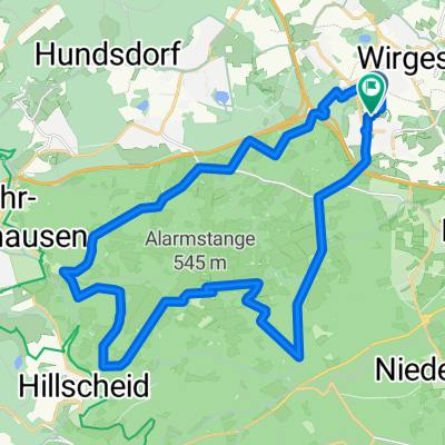
Dr-Domarus-Straße 14, Dernbach nach Dr-Domarus-Straße 17A, Dernbach
A cycling route starting in Dernbach, Rhineland-Palatinate, Germany.
Overview
About this route
- 43 min
- Duration
- 3.4 km
- Distance
- 69 m
- Ascent
- 44 m
- Descent
- 4.8 km/h
- Avg. speed
- 293 m
- Avg. speed
Route quality
Waytypes & surfaces along the route
Waytypes
Quiet road
1.7 km
(50 %)
Track
1.2 km
(36 %)
Surfaces
Paved
2.5 km
(71 %)
Unpaved
0.8 km
(25 %)
Paved (undefined)
2.3 km
(67 %)
Gravel
0.5 km
(16 %)
Continue with Bikemap
Use, edit, or download this cycling route
You would like to ride Dr-Domarus-Straße 14, Dernbach nach Dr-Domarus-Straße 17A, Dernbach or customize it for your own trip? Here is what you can do with this Bikemap route:
Free features
- Save this route as favorite or in collections
- Copy & plan your own version of this route
- Sync your route with Garmin or Wahoo
Premium features
Free trial for 3 days, or one-time payment. More about Bikemap Premium.
- Navigate this route on iOS & Android
- Export a GPX / KML file of this route
- Create your custom printout (try it for free)
- Download this route for offline navigation
Discover more Premium features.
Get Bikemap PremiumFrom our community
Other popular routes starting in Dernbach
 Elgendorf-Wirzenborn-Heiligenroth-Montabaur-Horressen-Elgendorf
- Distance
- 19.5 km
- Ascent
- 261 m
- Descent
- 261 m
- Location
- Dernbach, Rhineland-Palatinate, Germany
 Dr-Domarus-Straße 14, Dernbach nach Dr-Domarus-Straße 17A, Dernbach
- Distance
- 3.4 km
- Ascent
- 69 m
- Descent
- 44 m
- Location
- Dernbach, Rhineland-Palatinate, Germany
 Dernbach-Köppel
- Distance
- 21.2 km
- Ascent
- 395 m
- Descent
- 395 m
- Location
- Dernbach, Rhineland-Palatinate, Germany
 Dernbach-Ettinghausen-Weidenhahn-Dernbach
- Distance
- 30.2 km
- Ascent
- 354 m
- Descent
- 354 m
- Location
- Dernbach, Rhineland-Palatinate, Germany
 Dernbach Flürchen Sendeantenne Dernbach
- Distance
- 27.1 km
- Ascent
- 467 m
- Descent
- 468 m
- Location
- Dernbach, Rhineland-Palatinate, Germany
 Montabaur_Münstermaifeld via Schrumpftal
- Distance
- 95.5 km
- Ascent
- 493 m
- Descent
- 698 m
- Location
- Dernbach, Rhineland-Palatinate, Germany
 Tagesfahrt rund um den unteren Westerwald
- Distance
- 110.4 km
- Ascent
- 463 m
- Descent
- 463 m
- Location
- Dernbach, Rhineland-Palatinate, Germany
 Dernbach nach Deutsche Eck
- Distance
- 27 km
- Ascent
- 497 m
- Descent
- 692 m
- Location
- Dernbach, Rhineland-Palatinate, Germany
Open it in the app