

COL DE L'ARPETTAZ (por Ugine)
A cycling route starting in Ugine, Auvergne-Rhône-Alpes, France.
Overview
About this route
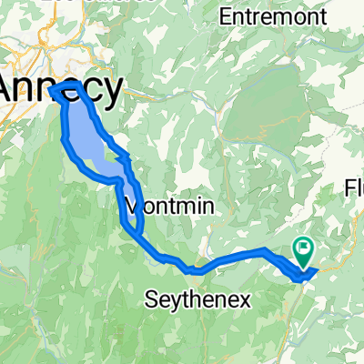
El Col de l’Arpettaz es un puerto de montaña situado en la región de Auvernia-Ródano-Alpes, en el sureste de Francia. Más concretamente, se encuentra en el departamento de Alta Saboya, cerca de la localidad de Ugine, a las puertas del macizo de Aravis. Este paso conecta la cuenca de Ugine con el altiplano alpino, ofreciendo vistas espectaculares de los paisajes montañosos, incluyendo el emblemático Mont Blanc en días despejados.
- 1 h 7 min
- Duration
- 15.8 km
- Distance
- 1,277 m
- Ascent
- 109 m
- Descent
- 14.2 km/h
- Avg. speed
- 1,582 m
- Avg. speed

Route photos
\"")
Route quality
Waytypes & surfaces along the route
Waytypes
Quiet road
15 km
(95 %)
Busy road
0.8 km
(5 %)
Surfaces
Paved
15.3 km
(97 %)
Unpaved
0 km
(<1 %)
Asphalt
15.3 km
(97 %)
Gravel
0 km
(<1 %)
Undefined
0.5 km
(3 %)
Continue with Bikemap
Use, edit, or download this cycling route
You would like to ride COL DE L'ARPETTAZ (por Ugine) or customize it for your own trip? Here is what you can do with this Bikemap route:
Free features
- Save this route as favorite or in collections
- Copy & plan your own version of this route
- Sync your route with Garmin or Wahoo
Premium features
Free trial for 3 days, or one-time payment. More about Bikemap Premium.
- Navigate this route on iOS & Android
- Export a GPX / KML file of this route
- Create your custom printout (try it for free)
- Download this route for offline navigation
Discover more Premium features.
Get Bikemap PremiumFrom our community
Other popular routes starting in Ugine
 Col Aperttaz via Ugine
- Distance
- 16.3 km
- Ascent
- 1,272 m
- Descent
- 114 m
- Location
- Ugine, Auvergne-Rhône-Alpes, France
 Ugine - Le Giettaz 56km
- Distance
- 55 km
- Ascent
- 2,175 m
- Descent
- 2,175 m
- Location
- Ugine, Auvergne-Rhône-Alpes, France
 Col de l'Arpettaz
- Distance
- 35.9 km
- Ascent
- 1,203 m
- Descent
- 1,203 m
- Location
- Ugine, Auvergne-Rhône-Alpes, France
 Arpettaz-Saisies-Forclaz
- Distance
- 84.7 km
- Ascent
- 2,377 m
- Descent
- 2,385 m
- Location
- Ugine, Auvergne-Rhône-Alpes, France
 Ugine - Aviernoz
- Distance
- 88.4 km
- Ascent
- 2,011 m
- Descent
- 1,651 m
- Location
- Ugine, Auvergne-Rhône-Alpes, France
 Col de Larpettaz vanuit Ugine
- Distance
- 35.4 km
- Ascent
- 1,189 m
- Descent
- 1,181 m
- Location
- Ugine, Auvergne-Rhône-Alpes, France
 test_tout_du_lac_Annecy_1023
- Distance
- 77.9 km
- Ascent
- 613 m
- Descent
- 614 m
- Location
- Ugine, Auvergne-Rhône-Alpes, France
 Annecy 4; Ugine
- Distance
- 85.2 km
- Ascent
- 2,411 m
- Descent
- 2,396 m
- Location
- Ugine, Auvergne-Rhône-Alpes, France
Open it in the app