

Giro delle tre province
A cycling route starting in Piancastagnaio, Tuscany, Italy.
Overview
About this route
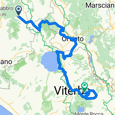
Un impegnativo percorso che si snoda attarverso tre province, quella di Siena, quella di Grosseto e quella di Viterbo. Il tracciato è molto bello e vario. Lungo circa 70 Km con un dislivello in salita di oltre mille metri e con due discese di media difficoltà.
- -:--
- Duration
- 69.2 km
- Distance
- 791 m
- Ascent
- 791 m
- Descent
- ---
- Avg. speed
- ---
- Avg. speed

Route quality
Waytypes & surfaces along the route
Waytypes
Busy road
57.7 km
(83 %)
Track
5.3 km
(8 %)
Surfaces
Paved
62.1 km
(90 %)
Unpaved
4.6 km
(7 %)
Asphalt
61.8 km
(89 %)
Unpaved (undefined)
3.1 km
(5 %)
Route highlights
Points of interest along the route
Point of interest after 4.2 km
Girare a sinistra lasciando la SP18 e prendere la SP 34 di Selvena
Point of interest after 10.6 km
Allo stop girare a sinistra e prendere la Provinciale 4 in direzione Castell'Azzara
Point of interest after 16.1 km
Nel paese di Castell'Azzara trovate una fontanella per eventuale rifornimento.
Point of interest after 30.7 km
Girare a sinistra in direzione Acquapendente. Questo tratto di strada nella provincia di Viterbo è più stretto ma in gran parte all'ombra e molto bello.
Point of interest after 43.2 km
Si entra ad Acquapendente ultima cittadina Laziale nella provincia di Viterbo. All'incrocio girare a sinistra e prendere la SS2 Cassia in direzione Siena.
Drinking water after 43.4 km
Lungo la discesa che porta fuori il paese c'è un negozio con officina meccanica per assistenza.
Point of interest after 56.8 km
Abbandonare la Strada Statale 2 Cassia e prendere a sinistra per le famose "girate". Questa strada vi riporterà, snodandosi in salita a Piancastagnaio.
Continue with Bikemap
Use, edit, or download this cycling route
You would like to ride Giro delle tre province or customize it for your own trip? Here is what you can do with this Bikemap route:
Free features
- Save this route as favorite or in collections
- Copy & plan your own version of this route
- Sync your route with Garmin or Wahoo
Premium features
Free trial for 3 days, or one-time payment. More about Bikemap Premium.
- Navigate this route on iOS & Android
- Export a GPX / KML file of this route
- Create your custom printout (try it for free)
- Download this route for offline navigation
Discover more Premium features.
Get Bikemap PremiumFrom our community
Other popular routes starting in Piancastagnaio
 Giro delle tre province
- Distance
- 69.2 km
- Ascent
- 791 m
- Descent
- 791 m
- Location
- Piancastagnaio, Tuscany, Italy
 IL GIRO DEL MONTE AMIATA
- Distance
- 65.9 km
- Ascent
- 1,050 m
- Descent
- 1,062 m
- Location
- Piancastagnaio, Tuscany, Italy
 3. Piancastagnaio - Monte Cimino
- Distance
- 177.4 km
- Ascent
- 2,690 m
- Descent
- 2,518 m
- Location
- Piancastagnaio, Tuscany, Italy
 Frankovska_D_21
- Distance
- 101.4 km
- Ascent
- 854 m
- Descent
- 1,342 m
- Location
- Piancastagnaio, Tuscany, Italy
 2019-6 Santa Fiora
- Distance
- 53.7 km
- Ascent
- 966 m
- Descent
- 960 m
- Location
- Piancastagnaio, Tuscany, Italy
 La Via dei Ruderi
- Distance
- 14.6 km
- Ascent
- 377 m
- Descent
- 377 m
- Location
- Piancastagnaio, Tuscany, Italy
 amiata campi bisenzio
- Distance
- 161.9 km
- Ascent
- 1,033 m
- Descent
- 1,766 m
- Location
- Piancastagnaio, Tuscany, Italy
 Giro del Monte Amiata
- Distance
- 58 km
- Ascent
- 977 m
- Descent
- 977 m
- Location
- Piancastagnaio, Tuscany, Italy
Open it in the app