

Glenora Napanee Picton
A cycling route starting in Picton, Ontario, Canada.
Overview
About this route
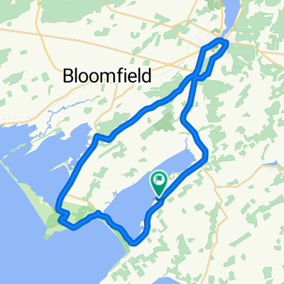
Starting at Mary St parking lot at 8am, heading to the ferry for 8:30 a then following the South shore of Hay Bay and then
heading to Napanee, back to 49 over the bridge and thru Green Point to Fish Lake Road, then Bethesda and Elmbrook and back to Picton
- -:--
- Duration
- 93.6 km
- Distance
- 209 m
- Ascent
- 207 m
- Descent
- ---
- Avg. speed
- ---
- Avg. speed

Route quality
Waytypes & surfaces along the route
Waytypes
Busy road
55.2 km
(59 %)
Quiet road
22.4 km
(24 %)
Surfaces
Paved
63.3 km
(68 %)
Unpaved
1.2 km
(1 %)
Asphalt
53 km
(57 %)
Paved (undefined)
10.2 km
(11 %)
Continue with Bikemap
Use, edit, or download this cycling route
You would like to ride Glenora Napanee Picton or customize it for your own trip? Here is what you can do with this Bikemap route:
Free features
- Save this route as favorite or in collections
- Copy & plan your own version of this route
- Sync your route with Garmin or Wahoo
Premium features
Free trial for 3 days, or one-time payment. More about Bikemap Premium.
- Navigate this route on iOS & Android
- Export a GPX / KML file of this route
- Create your custom printout (try it for free)
- Download this route for offline navigation
Discover more Premium features.
Get Bikemap PremiumFrom our community
Other popular routes starting in Picton
 Longer loop (East Lake, Picton)
- Distance
- 42 km
- Ascent
- 165 m
- Descent
- 165 m
- Location
- Picton, Ontario, Canada
 Mac's Memorial (Picon Stage)
- Distance
- 19.5 km
- Ascent
- 163 m
- Descent
- 163 m
- Location
- Picton, Ontario, Canada
 Sandbanks 38km
- Distance
- 38.3 km
- Ascent
- 143 m
- Descent
- 143 m
- Location
- Picton, Ontario, Canada
 Picton Pleasant Bay
- Distance
- 70.4 km
- Ascent
- 124 m
- Descent
- 124 m
- Location
- Picton, Ontario, Canada
 Rob's ride, May 21st.
- Distance
- 45.4 km
- Ascent
- 131 m
- Descent
- 126 m
- Location
- Picton, Ontario, Canada
 East Lake Express
- Distance
- 41.4 km
- Ascent
- 109 m
- Descent
- 109 m
- Location
- Picton, Ontario, Canada
 Picton
- Distance
- 35.5 km
- Ascent
- 192 m
- Descent
- 186 m
- Location
- Picton, Ontario, Canada
 Prince Edward County
- Distance
- 54.9 km
- Ascent
- 251 m
- Descent
- 251 m
- Location
- Picton, Ontario, Canada
Open it in the app