

Teiche-Radroute
A cycling route starting in Waidhofen an der Thaya, Lower Austria, Austria.
Overview
About this route
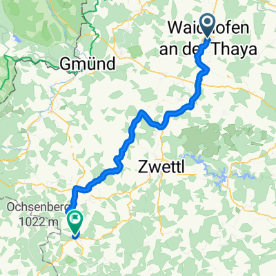
Die Teiche-Radroute ist ein Radrundweg und Teil des regionalen Radfahr-Konzeptes der 5-Sinne-Radrunden ("Hören") des Zukunftsraumes Thayaland.
- -:--
- Duration
- 54.7 km
- Distance
- 539 m
- Ascent
- 538 m
- Descent
- ---
- Avg. speed
- 624 m
- Avg. speed

Route quality
Waytypes & surfaces along the route
Waytypes
Quiet road
23 km
(42 %)
Road
14.2 km
(26 %)
Surfaces
Paved
23.2 km
(42 %)
Unpaved
0.9 km
(2 %)
Asphalt
19.2 km
(35 %)
Paved (undefined)
4 km
(7 %)
Continue with Bikemap
Use, edit, or download this cycling route
You would like to ride Teiche-Radroute or customize it for your own trip? Here is what you can do with this Bikemap route:
Free features
- Save this route as favorite or in collections
- Copy & plan your own version of this route
- Sync your route with Garmin or Wahoo
Premium features
Free trial for 3 days, or one-time payment. More about Bikemap Premium.
- Navigate this route on iOS & Android
- Export a GPX / KML file of this route
- Create your custom printout (try it for free)
- Download this route for offline navigation
Discover more Premium features.
Get Bikemap PremiumFrom our community
Other popular routes starting in Waidhofen an der Thaya
 17.April 2.3
- Distance
- 31.2 km
- Ascent
- 270 m
- Descent
- 256 m
- Location
- Waidhofen an der Thaya, Lower Austria, Austria
 4. Radwandertag RLH Waidhofen/Th
- Distance
- 19.4 km
- Ascent
- 126 m
- Descent
- 128 m
- Location
- Waidhofen an der Thaya, Lower Austria, Austria
 Waidhofen an der Thaya - Heidenreichstein 41 Km
- Distance
- 42.8 km
- Ascent
- 522 m
- Descent
- 518 m
- Location
- Waidhofen an der Thaya, Lower Austria, Austria
 Waidhofen -Richtung Westen nach Gmünd und retour, 72 km
- Distance
- 73.3 km
- Ascent
- 419 m
- Descent
- 408 m
- Location
- Waidhofen an der Thaya, Lower Austria, Austria
 Teiche-Radroute
- Distance
- 54.7 km
- Ascent
- 539 m
- Descent
- 538 m
- Location
- Waidhofen an der Thaya, Lower Austria, Austria
 Waidhofen - Arbesbach
- Distance
- 63.2 km
- Ascent
- 1,007 m
- Descent
- 715 m
- Location
- Waidhofen an der Thaya, Lower Austria, Austria
 Strecke Waidhofen Waldviertler Radtage 2025
- Distance
- 17.5 km
- Ascent
- 262 m
- Descent
- 260 m
- Location
- Waidhofen an der Thaya, Lower Austria, Austria
 Waidhofen Vestenötting Meires
- Distance
- 20.3 km
- Ascent
- 205 m
- Descent
- 203 m
- Location
- Waidhofen an der Thaya, Lower Austria, Austria
Open it in the app