

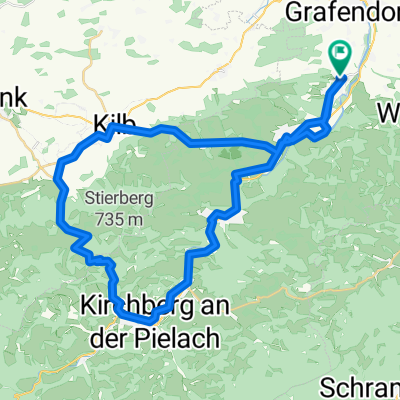
2025_Tonach-Purgstall
A cycling route starting in Weinburg, Lower Austria, Austria.
Overview
About this route
- 5 h 50 min
- Duration
- 102.2 km
- Distance
- 869 m
- Ascent
- 871 m
- Descent
- 17.5 km/h
- Avg. speed
- 448 m
- Avg. speed

Route quality
Waytypes & surfaces along the route
Waytypes
Road
52.9 km
(52 %)
Quiet road
27.5 km
(27 %)
Surfaces
Paved
52.5 km
(51 %)
Unpaved
1.3 km
(1 %)
Asphalt
51.9 km
(51 %)
Gravel
0.7 km
(<1 %)
Continue with Bikemap
Use, edit, or download this cycling route
You would like to ride 2025_Tonach-Purgstall or customize it for your own trip? Here is what you can do with this Bikemap route:
Free features
- Save this route as favorite or in collections
- Copy & plan your own version of this route
- Sync your route with Garmin or Wahoo
Premium features
Free trial for 3 days, or one-time payment. More about Bikemap Premium.
- Navigate this route on iOS & Android
- Export a GPX / KML file of this route
- Create your custom printout (try it for free)
- Download this route for offline navigation
Discover more Premium features.
Get Bikemap PremiumFrom our community
Other popular routes starting in Weinburg
 Weinburg-Luft-Kilb-Obergrafendorf-Weinburg
- Distance
- 57.1 km
- Ascent
- 426 m
- Descent
- 427 m
- Location
- Weinburg, Lower Austria, Austria
 2025_Tonach-Purgstall
- Distance
- 102.2 km
- Ascent
- 869 m
- Descent
- 871 m
- Location
- Weinburg, Lower Austria, Austria
 Rundkurs
- Distance
- 19.6 km
- Ascent
- 418 m
- Descent
- 417 m
- Location
- Weinburg, Lower Austria, Austria
 17.03.2021 Hofstetten-Pielach-Traisentalradweg
- Distance
- 60.9 km
- Ascent
- 366 m
- Descent
- 366 m
- Location
- Weinburg, Lower Austria, Austria
 Luft Rundfahrt
- Distance
- 45.6 km
- Ascent
- 547 m
- Descent
- 547 m
- Location
- Weinburg, Lower Austria, Austria
 Steady ride in St. Pölten
- Distance
- 13.6 km
- Ascent
- 48 m
- Descent
- 50 m
- Location
- Weinburg, Lower Austria, Austria
 Trainingsrunde f. STP Radmarathon Extreme
- Distance
- 125.4 km
- Ascent
- 1,757 m
- Descent
- 1,757 m
- Location
- Weinburg, Lower Austria, Austria
 Mank-Panoramastrasse-Bischofstetten
- Distance
- 51.9 km
- Ascent
- 561 m
- Descent
- 567 m
- Location
- Weinburg, Lower Austria, Austria
Open it in the app