
EV 7 | Italy | lifeintravel.it
A cycling route starting in Montale, Tuscany, Italy.
Overview
About this route
Statistiche calcolate sui dati importatiDistanza: 2201,1 kmAltezza minima: 1 mAltezza massima: 1216 mSalita accumulata: 11220 mDiscesa accumulata: 12314 m
- 25 h 27 min
- Duration
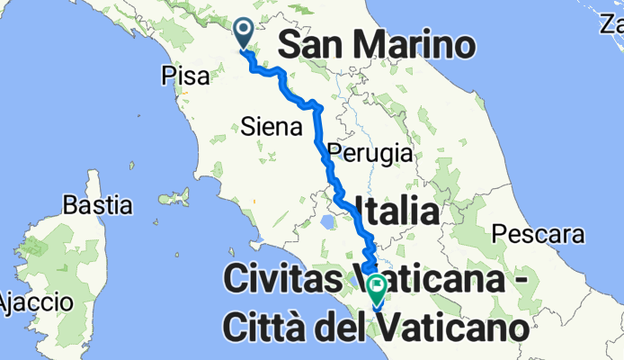
- 388.5 km
- Distance
- 3,884 m
- Ascent
- 3,945 m
- Descent
- 15.3 km/h
- Avg. speed
- 542 m
- Avg. speed

Continue with Bikemap
Use, edit, or download this cycling route
You would like to ride EV 7 | Italy | lifeintravel.it or customize it for your own trip? Here is what you can do with this Bikemap route:
Free features
- Save this route as favorite or in collections
- Copy & plan your own version of this route
- Sync your route with Garmin or Wahoo
Premium features
Free trial for 3 days, or one-time payment. More about Bikemap Premium.
- Navigate this route on iOS & Android
- Export a GPX / KML file of this route
- Create your custom printout (try it for free)
- Download this route for offline navigation
Discover more Premium features.
Get Bikemap PremiumFrom our community
Other popular routes starting in Montale
 EV 7 | Italy | lifeintravel.it
- Distance
- 388.5 km
- Ascent
- 3,884 m
- Descent
- 3,945 m
- Location
- Montale, Tuscany, Italy
 Assisi_4
- Distance
- 244.5 km
- Ascent
- 826 m
- Descent
- 775 m
- Location
- Montale, Tuscany, Italy
 Da Montemurlo (PO) al Cinquale (MS)
- Distance
- 115.5 km
- Ascent
- 1,341 m
- Descent
- 1,410 m
- Location
- Montale, Tuscany, Italy
 Montale -monachino - cantagallo - Vernio - Vaiano
- Distance
- 72.1 km
- Ascent
- 1,427 m
- Descent
- 1,427 m
- Location
- Montale, Tuscany, Italy
 Montemurlo-Acquerino-Lentula-Vaiano
- Distance
- 73.3 km
- Ascent
- 1,451 m
- Descent
- 1,453 m
- Location
- Montale, Tuscany, Italy
 Montale_Giro Rifugi Acquerino Cantagallo
- Distance
- 66 km
- Ascent
- 2,726 m
- Descent
- 2,727 m
- Location
- Montale, Tuscany, Italy
 Peda..Lando e C.
- Distance
- 20.7 km
- Ascent
- 770 m
- Descent
- 800 m
- Location
- Montale, Tuscany, Italy
 4 Montale - Vignola
- Distance
- 108.5 km
- Ascent
- 1,584 m
- Descent
- 1,535 m
- Location
- Montale, Tuscany, Italy
Open it in the app