

Zum "Frau Holle Teich" und zurück.
A cycling route starting in Borken, Hesse, Germany.
Overview
About this route
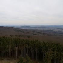
Sehr schöne Route für das Rennrad. Unser Ziel ist der "Frau Holle Teich" auf dem Hohen Meißner. Hier erwartet und der steilste Anstieg auf der Strecke. Rund 350 Höhenmeter auf einer Länge von 4,6 Kilometern müssen bezwungen werden.
Die letzten 20 Kilometer sind zum Ende relativ flach- ideal zum ausrollen.
- -:--
- Duration
- 142.9 km
- Distance
- 1,407 m
- Ascent
- 1,407 m
- Descent
- ---
- Avg. speed
- ---
- Avg. speed
Route quality
Waytypes & surfaces along the route
Waytypes
Busy road
103.3 km
(72 %)
Road
15.1 km
(11 %)
Surfaces
Paved
114.4 km
(80 %)
Unpaved
4.5 km
(3 %)
Asphalt
112.9 km
(79 %)
Ground
2.4 km
(2 %)
Continue with Bikemap
Use, edit, or download this cycling route
You would like to ride Zum "Frau Holle Teich" und zurück. or customize it for your own trip? Here is what you can do with this Bikemap route:
Free features
- Save this route as favorite or in collections
- Copy & plan your own version of this route
- Sync your route with Garmin or Wahoo
Premium features
Free trial for 3 days, or one-time payment. More about Bikemap Premium.
- Navigate this route on iOS & Android
- Export a GPX / KML file of this route
- Create your custom printout (try it for free)
- Download this route for offline navigation
Discover more Premium features.
Get Bikemap PremiumFrom our community
Other popular routes starting in Borken
 Schatz Fahrrad tour
- Distance
- 8.9 km
- Ascent
- 148 m
- Descent
- 136 m
- Location
- Borken, Hesse, Germany
 Borken Treysa QUERFELD ein
- Distance
- 19.2 km
- Ascent
- 199 m
- Descent
- 194 m
- Location
- Borken, Hesse, Germany
 Grossenenglis-Uttershausen-zurück
- Distance
- 20.1 km
- Ascent
- 96 m
- Descent
- 97 m
- Location
- Borken, Hesse, Germany
 Rundtour 2//Felsberg
- Distance
- 36.7 km
- Ascent
- 195 m
- Descent
- 193 m
- Location
- Borken, Hesse, Germany
 Eisenberg-KnüllTour
- Distance
- 91 km
- Ascent
- 970 m
- Descent
- 978 m
- Location
- Borken, Hesse, Germany
 the tower
- Distance
- 32.7 km
- Ascent
- 737 m
- Descent
- 706 m
- Location
- Borken, Hesse, Germany
 Borken ABENDRUNDE 1.0
- Distance
- 9.6 km
- Ascent
- 176 m
- Descent
- 178 m
- Location
- Borken, Hesse, Germany
 Zuhause-Gombeth
- Distance
- 20.2 km
- Ascent
- 118 m
- Descent
- 126 m
- Location
- Borken, Hesse, Germany
Open it in the app